Zollikon night lights from space
Night Light of Zollikon (Zurich) from space (Switzerland) Src. Average luminocity for 10x10km area is 51.4628% and for 50x50km: 17.6579%.
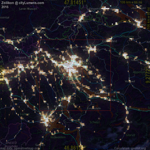
Analysis of Zollikon night lights 2016
Square area 10x10 km:
 11.9%
11.9%90-99
11.9%80-89
3.13%70-79
3.57%60-69
7.29%50-59
4.91%40-49
9.97%30-39
11.46%20-29
16.67%10-19
18.15%0-9
1.04%Square area 50x50 km:
2.74%90-99
2.8%80-89
1.28%70-79
1.69%60-69
2.35%50-59
2.02%40-49
2.86%30-39
2.84%20-29
4.39%10-19
15.22%0-9
61.81%Clear (daylight) street map image can be seen on geolist.org.
Map coordinates:
47° 48' 52.2" North, 7° 52' 15.4" East
47° 20' 24.7" North, 8° 34' 26.7" East
46° 51' 41.7" North, 9° 16' 37.9" East
Some cities around Zollikon sort by population:
• Zürich (Kreis 2) / Wollishofen
3.2 km =2 mi,  269°
269°
• Zürich (Kreis 8)
1.9 km =1.2 mi,  328°
328°
• Küsnacht
2.6 km =1.6 mi,  163°
163°
• Zürich (Kreis 7) / Hottingen
3.4 km =2.1 mi,  346°
346°
• Zürich (Kreis 7) / Witikon
2.3 km =1.4 mi,  33°
33°
• Zürich (Kreis 7) / Hirslanden
2.5 km =1.6 mi, 348°
• Kilchberg
2.8 km =1.7 mi,  230°
230°
• Zürich (Kreis 8) / Mühlebach
2.3 km =1.4 mi, 326°
2657912 (p: 5,812)
Sources (retrieved 2019-11-25):
» Earth at Night: Flat Maps 2012, 2016