Zürich (Kreis 2) / Wollishofen night lights from space
Night Light of Zürich (Kreis 2) / Wollishofen (Zurich) from space (Switzerland) Src. Average luminocity for 10x10km area is 54.9688% and for 50x50km: 18.2714%.
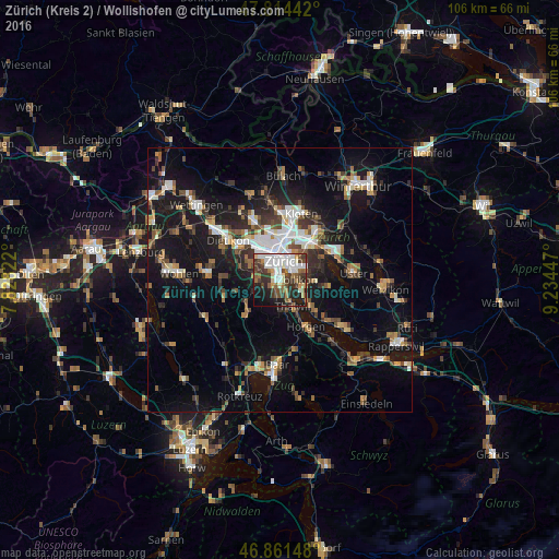
Analysis of Zürich (Kreis 2) / Wollishofen night lights 2016
Square area 10x10 km:
 14.88%
90-99
12.05%80-89
3.57%70-79
4.02%60-69
7.44%50-59
5.36%40-49
12.2%30-39
11.76%20-29
12.05%10-19
14.43%0-9
2.23%Square area 50x50 km:
2.74%90-99
2.9%80-89
1.28%70-79
1.62%60-69
2.49%50-59
2.28%40-49
2.93%30-39
3%20-29
4.57%10-19
16.59%0-9
59.6%Clear (daylight) street map image can be seen on geolist.org.
Map coordinates:
47° 48' 51.9" North, 7° 49' 41.6" East
47° 20' 24.4" North, 8° 31' 52.8" East
46° 51' 41.3" North, 9° 14' 4.1" East
Some cities around Zürich (Kreis 2) / Wollishofen sort by population:
• Zürich
3.3 km =2.1 mi,  25°
25°
• Adliswil
3.4 km =2.1 mi,  188°
188°
• Thalwil
5.9 km =3.7 mi,  155°
155°
• Küsnacht
4.7 km =2.9 mi,  121°
121°
• Langnau am Albis
5.7 km =3.5 mi,  172°
172°
• Thalwil / Dorfkern
6.1 km =3.8 mi,  154°
154°
• Kilchberg
2 km =1.2 mi, 148°
• Zollikon
3.2 km =2 mi,  89°
89°
6295495 (p: 16,073)
Sources (retrieved 2019-11-25):
» Earth at Night: Flat Maps 2012, 2016