Thalwil night lights from space
Night Light of Thalwil (Zurich) from space (Switzerland) Src. Average luminocity for 10x10km area is 26.5551% and for 50x50km: 18.3698%.
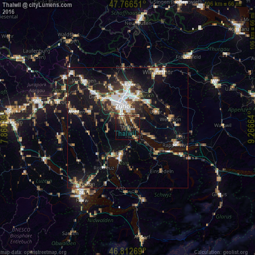
Analysis of Thalwil night lights 2016
Square area 10x10 km:
 0.3%
0.3%90-99
1.79%80-89
1.93%70-79
3.42%60-69
6.55%50-59
4.32%40-49
6.99%30-39
5.51%20-29
13.24%10-19
27.08%0-9
28.87%Square area 50x50 km:
2.76%90-99
2.93%80-89
1.31%70-79
1.73%60-69
2.54%50-59
2.17%40-49
3.07%30-39
3.1%20-29
4.86%10-19
15.92%0-9
59.62%Clear (daylight) street map image can be seen on geolist.org.
Map coordinates:
47° 45' 59.4" North, 7° 51' 37.4" East
47° 17' 30.3" North, 8° 33' 48.6" East
46° 48' 45.7" North, 9° 15' 59.9" East
Some cities around Thalwil sort by population:
• Horgen
4.4 km =2.7 mi,  143°
143°
• Adliswil
3.6 km =2.2 mi,  304°
304°
• Küsnacht
3.3 km =2.1 mi,  27°
27°
• Langnau am Albis
1.7 km =1.1 mi,  259°
259°
• Kilchberg
3.9 km =2.4 mi,  339°
339°
• Horgen / Horgen (Dorfkern)
4.9 km =3 mi, 144°
• Zollikon
5.4 km =3.4 mi,  8°
8°
• Herrliberg
3.9 km =2.4 mi,  91°
91°
2658388 (p: 13,296)
Sources (retrieved 2019-11-25):
» Earth at Night: Flat Maps 2012, 2016