Lengnau night lights from space
Night Light of Lengnau (Bern) from space (Switzerland) Src. Average luminocity for 10x10km area is 22.7188% and for 50x50km: 10.7567%.
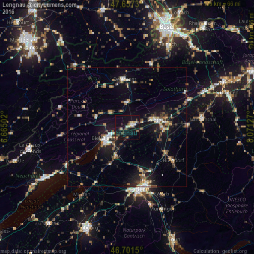
Analysis of Lengnau night lights 2016
Square area 10x10 km:
 1.64%
1.64%90-99
2.53%80-89
5.06%70-79
2.08%60-69
1.19%50-59
3.13%40-49
3.57%30-39
2.98%20-29
1.49%10-19
41.67%0-9
34.67%Square area 50x50 km:
0.94%90-99
1.4%80-89
0.93%70-79
1.08%60-69
1.32%50-59
1.53%40-49
1.8%30-39
1.86%20-29
2.78%10-19
9.11%0-9
77.25%Clear (daylight) street map image can be seen on geolist.org.
Map coordinates:
47° 39' 26.3" North, 6° 39' 54.1" East
47° 10' 53.6" North, 7° 22' 5.3" East
46° 42' 5.4" North, 8° 4' 16.6" East
Some cities around Lengnau sort by population:
• Biel/Bienne
10.5 km =6.5 mi,  241°
241°
• Grenchen
2.4 km =1.5 mi,  60°
60°
• Solothurn
13.1 km =8.1 mi,  77°
77°
• Lyss
12.8 km =8 mi,  201°
201°
• Zuchwil
15.2 km =9.4 mi, 81°
• Biberist
14.7 km =9.1 mi,  90°
90°
• Moutier
10.7 km =6.6 mi,  0°
0°
• Nidau
11.5 km =7.1 mi, 237°
2659957 (p: 7,336)
Sources (retrieved 2019-11-25):
» Earth at Night: Flat Maps 2012, 2016