Buchs night lights from space
Night Light of Buchs (Aargau) from space (Switzerland) Src. Average luminocity for 10x10km area is 36.3622% and for 50x50km: 14.9929%.
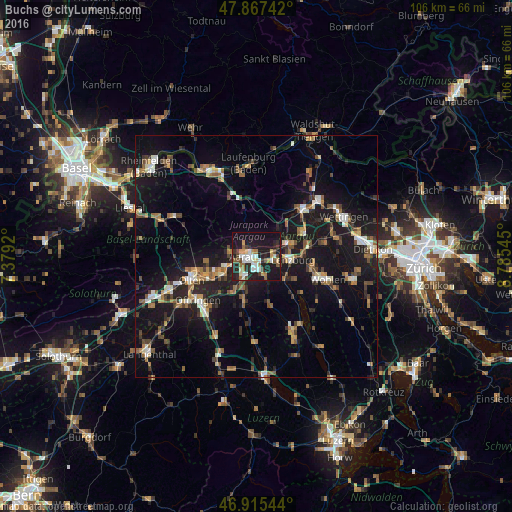
Analysis of Buchs night lights 2016
Square area 10x10 km:
 5.54%
5.54%90-99
7.67%80-89
2.84%70-79
4.4%60-69
4.26%50-59
3.27%40-49
5.11%30-39
3.27%20-29
15.2%10-19
40.91%0-9
7.53%Square area 50x50 km:
1.28%90-99
1.98%80-89
1.04%70-79
1.45%60-69
2.41%50-59
2.19%40-49
2.37%30-39
2.14%20-29
3.83%10-19
18.52%0-9
62.78%Clear (daylight) street map image can be seen on geolist.org.
Map coordinates:
47° 52' 2.7" North, 7° 22' 45.1" East
47° 23' 36.9" North, 8° 4' 56.4" East
46° 54' 55.6" North, 8° 47' 7.6" East
Some cities around Buchs sort by population:
• Aarau
2.9 km =1.8 mi,  267°
267°
• Suhr
2.4 km =1.5 mi,  184°
184°
• Brugg
13.6 km =8.5 mi,  44°
44°
• Oberentfelden
5 km =3.1 mi,  213°
213°
• Lenzburg
7 km =4.3 mi,  94°
94°
• Gränichen
4.1 km =2.5 mi,  158°
158°
• Villmergen
13.4 km =8.3 mi,  111°
111°
• Küttigen
3.4 km =2.1 mi,  313°
313°
2661348 (p: 6,599)
Sources (retrieved 2019-11-25):
» Earth at Night: Flat Maps 2012, 2016