Aarau night lights from space
Night Light of Aarau (Aargau) from space (Switzerland) Src. Average luminocity for 10x10km area is 37.4517% and for 50x50km: 15.2672%.
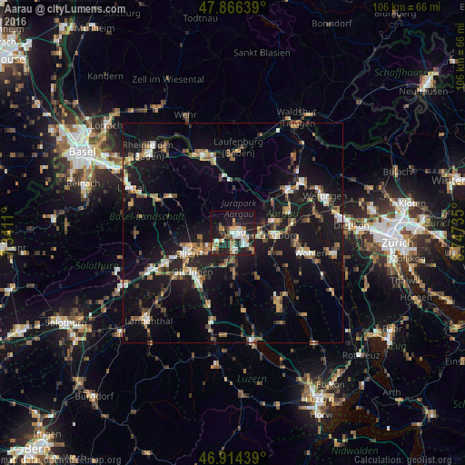
Analysis of Aarau night lights 2016
Square area 10x10 km:
100  5.54%
5.54%
90-99 8.38%
80-89 2.56%
70-79 4.4%
60-69 6.11%
50-59 2.98%
40-49 5.68%
30-39 2.84%
20-29 17.19%
10-19 31.53%
0-9 12.78%
5.54%90-99
8.38%80-89
2.56%70-79
4.4%60-69
6.11%50-59
2.98%40-49
5.68%30-39
2.84%20-29
17.19%10-19
31.53%0-9
12.78%Square area 50x50 km:
100 1.26%
90-99 2.04%
80-89 1.08%
70-79 1.56%
60-69 2.49%
50-59 2.2%
40-49 2.26%
30-39 2.15%
20-29 3.84%
10-19 18.7%
0-9 62.41%
1.26%90-99
2.04%80-89
1.08%70-79
1.56%60-69
2.49%50-59
2.2%40-49
2.26%30-39
2.15%20-29
3.84%10-19
18.7%0-9
62.41%Clear (daylight) street map image can be seen on geolist.org.
Map coordinates:
47° 51' 59" North, 7° 20' 28" East
47° 23' 33.1" North, 8° 2' 39.2" East
46° 54' 51.8" North, 8° 44' 50.5" East
Some cities around Aarau sort by population:
• Olten
11.6 km =7.2 mi,  245°
245°
• Suhr
3.5 km =2.2 mi,  130°
130°
• Oberentfelden
4 km =2.5 mi,  178°
178°
• Lenzburg
9.9 km =6.2 mi,  92°
92°
• Buchs
2.9 km =1.8 mi, 87°
• Gränichen
5.7 km =3.5 mi, 130°
• Trimbach
12.2 km =7.6 mi,  255°
255°
• Küttigen
2.5 km =1.6 mi,  9°
9°
2661881 (p: 15,501)
Sources (retrieved 2019-11-25):
» Earth at Night: Flat Maps 2012, 2016