Portage la Prairie night lights from space
Night Light of Portage la Prairie (Manitoba) from space (Canada) Src. Average luminocity for 10x10km area is 21.4594% and for 50x50km: 1.1024%.
Analysis of Portage la Prairie night lights 2016
Square area 10x10 km:
 3.64%
3.64%90-99
4.76%80-89
1.68%70-79
0.98%60-69
1.82%50-59
1.82%40-49
3.78%30-39
3.64%20-29
2.52%10-19
20.87%0-9
54.48%Square area 50x50 km:
0.17%90-99
0.21%80-89
0.09%70-79
0.04%60-69
0.07%50-59
0.11%40-49
0.2%30-39
0.18%20-29
0.22%10-19
0.9%0-9
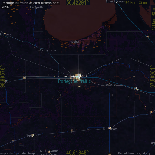
97.81%Clear (daylight) street map image can be seen on geolist.org.
Map coordinates:
50° 25' 22.5" North, 98° 59' 44.7" West
49° 58' 22.2" North, 98° 17' 33.5" West
49° 31' 6.5" North, 97° 35' 22.2" West
Some cities around Portage la Prairie sort by population:
• Winnipeg
82.6 km =51.3 mi,  96°
96°
• Brandon
119.7 km =74.4 mi,  263°
263°
• Selkirk
102.3 km =63.6 mi,  79°
79°
• Steinbach
125.8 km =78.2 mi,  113°
113°
• Dauphin
180.3 km =112 mi,  316°
316°
• Winkler
91.5 km =56.9 mi,  163°
163°
• Devils Lake, US
211 km =131.1 mi,  191°
191°
• Morden
87.9 km =54.6 mi,  170°
170°
6111529 (p: 12,957)
Sources (retrieved 2019-11-25):
» Earth at Night: Flat Maps 2012, 2016