Listowel night lights from space
Night Light of Listowel (Ontario) from space (Canada) Src. Average luminocity for 10x10km area is 11.8152% and for 50x50km: 1.2476%.
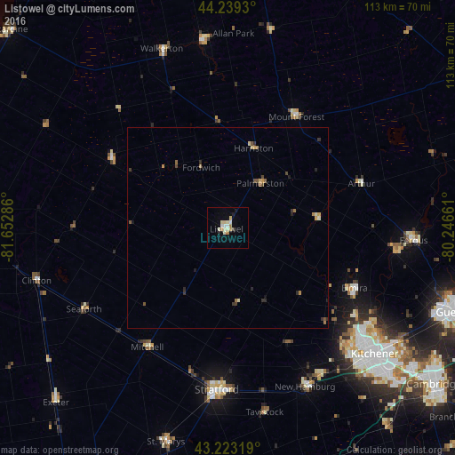
Analysis of Listowel night lights 2016
Square area 10x10 km:
 0.91%
0.91%90-99
4.09%80-89
2.12%70-79
0.15%60-69
2.42%50-59
0%40-49
0.45%30-39
0.15%20-29
0.3%10-19
2.42%0-9
86.97%Square area 50x50 km:
0.04%90-99
0.22%80-89
0.18%70-79
0.14%60-69
0.24%50-59
0.14%40-49
0.21%30-39
0.22%20-29
0.23%10-19
0.22%0-9
98.17%Clear (daylight) street map image can be seen on geolist.org.
Map coordinates:
44° 14' 21.5" North, 81° 39' 10.3" West
43° 44' 0.2" North, 80° 56' 59" West
43° 13' 23.5" North, 80° 14' 47.8" West
Some cities around Listowel sort by population:
• Kitchener
49.2 km =30.6 mi,  134°
134°
• Guelph
59.6 km =37 mi,  110°
110°
• Waterloo
45.8 km =28.5 mi, 130°
• Stratford
40.8 km =25.4 mi,  179°
179°
• New Hamburg
43.8 km =27.2 mi,  152°
152°
• North Perth
1.7 km =1.1 mi,  236°
236°
• Huron East
31 km =19.3 mi,  245°
245°
• Hanover
46.8 km =29.1 mi,  351°
351°
6054677 (p: 7,530)
Sources (retrieved 2019-11-25):
» Earth at Night: Flat Maps 2012, 2016