Tapejara night lights from space
Night Light of Tapejara (Rio Grande do Sul) from space (Brazil) Src. Average luminocity for 10x10km area is 15.5322% and for 50x50km: 2.3484%.
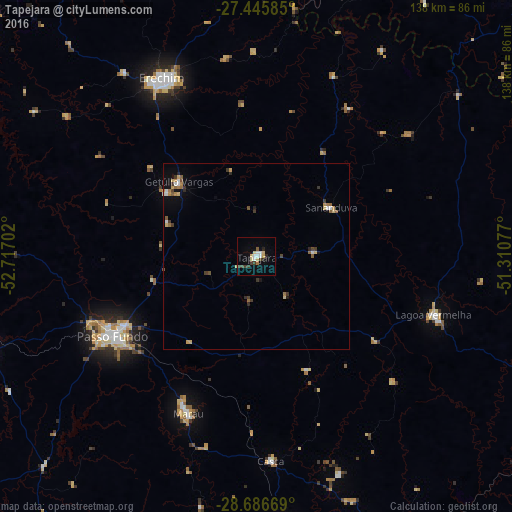
Analysis of Tapejara night lights 2016
Square area 10x10 km:
 3.03%
3.03%90-99
1.7%80-89
3.98%70-79
0.38%60-69
0.76%50-59
0.76%40-49
1.33%30-39
3.98%20-29
2.27%10-19
1.52%0-9
80.3%Square area 50x50 km:
0.3%90-99
0.18%80-89
0.46%70-79
0.26%60-69
0.33%50-59
0.32%40-49
0.21%30-39
0.58%20-29
0.31%10-19
0.5%0-9
96.54%Clear (daylight) street map image can be seen on geolist.org.
Map coordinates:
27° 26' 45.1" South, 52° 43' 1.3" West
28° 4' 5" South, 52° 0' 50" West
28° 41' 12.1" South, 51° 18' 38.8" West
Some cities around Tapejara sort by population:
• Passo Fundo
44.2 km =27.5 mi,  240°
240°
• Erechim
54.6 km =33.9 mi,  331°
331°
• Carazinho
79.4 km =49.3 mi,  252°
252°
• Marau
46.1 km =28.6 mi,  203°
203°
• Lagoa Vermelha
50.3 km =31.3 mi,  108°
108°
• Guaporé
87.3 km =54.2 mi,  172°
172°
• Celso Ramos
82.2 km =51.1 mi,  54°
54°
• Sananduva
24.2 km =15 mi,  57°
57°
3446922 (p: 14,064)
Sources (retrieved 2019-11-25):
» Earth at Night: Flat Maps 2012, 2016