Tabatinga night lights from space
Night Light of Tabatinga (São Paulo) from space (Brazil) Src. Average luminocity for 10x10km area is 7.7898% and for 50x50km: 3.7588%.
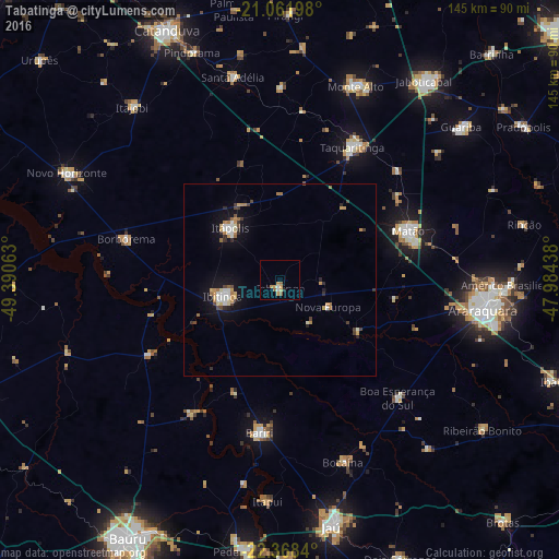
Analysis of Tabatinga night lights 2016
Square area 10x10 km:
 0.57%
0.57%90-99
0.95%80-89
0.76%70-79
3.79%60-69
0.38%50-59
1.89%40-49
0%30-39
0%20-29
0.76%10-19
0%0-9
90.91%Square area 50x50 km:
0.43%90-99
0.51%80-89
0.3%70-79
0.85%60-69
0.51%50-59
0.26%40-49
0.45%30-39
0.38%20-29
0.52%10-19
2.68%0-9
93.1%Clear (daylight) street map image can be seen on geolist.org.
Map coordinates:
21° 3' 43.1" South, 49° 23' 26.3" West
21° 43' 0" South, 48° 41' 15" West
22° 22' 6.2" South, 47° 59' 3.8" West
Some cities around Tabatinga sort by population:
• Araraquara
53.6 km =33.3 mi,  99°
99°
• Matão
35.5 km =22.1 mi,  69°
69°
• Taquaritinga
39.4 km =24.5 mi,  28°
28°
• Ibitinga
15.3 km =9.5 mi,  252°
252°
• Itápolis
18.7 km =11.6 mi,  316°
316°
• Bariri
40.2 km =25 mi,  187°
187°
• Borborema
41.3 km =25.7 mi,  285°
285°
• Boa Esperança do Sul
43.3 km =26.9 mi,  135°
135°
3447200 (p: 11,616)
Sources (retrieved 2019-11-25):
» Earth at Night: Flat Maps 2012, 2016