Sertânia night lights from space
Night Light of Sertânia (Pernambuco) from space (Brazil) Src. Average luminocity for 10x10km area is 12.4215% and for 50x50km: 2.0487%.
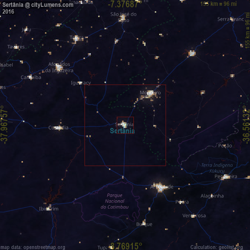
Analysis of Sertânia night lights 2016
Square area 10x10 km:
 1.65%
1.65%90-99
3.1%80-89
2.27%70-79
1.03%60-69
1.86%50-59
0%40-49
0%30-39
3.31%20-29
0%10-19
0.83%0-9
85.95%Square area 50x50 km:
0.16%90-99
0.34%80-89
0.26%70-79
0.08%60-69
0.17%50-59
0.44%40-49
0.29%30-39
0.55%20-29
0.35%10-19
0.95%0-9
96.42%Clear (daylight) street map image can be seen on geolist.org.
Map coordinates:
7° 22' 36.7" South, 37° 58' 3.3" West
8° 4' 25" South, 37° 15' 52" West
8° 46' 8.9" South, 36° 33' 40.8" West
Some cities around Sertânia sort by population:
• Arcoverde
44.8 km =27.8 mi,  148°
148°
• Afogados da Ingazeira
54.7 km =34 mi,  311°
311°
• Buíque
62.3 km =38.7 mi,  168°
168°
• Custódia
41.7 km =25.9 mi,  267°
267°
• Monteiro
25.9 km =16.1 mi,  37°
37°
• Tabira
61.6 km =38.3 mi,  330°
330°
• Pedra
59 km =36.7 mi,  142°
142°
• Sumé
61.6 km =38.3 mi, 43°
3387663 (p: 18,190)
Sources (retrieved 2019-11-25):
» Earth at Night: Flat Maps 2012, 2016