São João de Pirabas night lights from space
Night Light of São João de Pirabas (Pará) from space (Brazil) Src. Average luminocity for 10x10km area is 7.4719% and for 50x50km: 4.1502%.
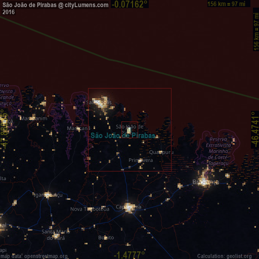
Analysis of São João de Pirabas night lights 2016
Square area 10x10 km:
 0.43%
0.43%90-99
0.43%80-89
4.33%70-79
0%60-69
0.87%50-59
0%40-49
0.87%30-39
0.87%20-29
1.52%10-19
0.22%0-9
90.48%Square area 50x50 km:
0.21%90-99
0.26%80-89
1.08%70-79
0.4%60-69
0.53%50-59
0.91%40-49
0.67%30-39
0.58%20-29
0.76%10-19
2.81%0-9
91.8%Clear (daylight) street map image can be seen on geolist.org.
Map coordinates:
0° 4' 17.8" South, 47° 52' 49.3" West
0° 46' 29" South, 47° 10' 38" West
1° 28' 39.7" South, 46° 28' 26.8" West
Some cities around São João de Pirabas sort by population:
• Bragança
55.3 km =34.4 mi,  124°
124°
• Capanema
46.8 km =29.1 mi,  180°
180°
• Salinópolis
26.8 km =16.7 mi,  312°
312°
• Igarapé Açu
63 km =39.1 mi,  231°
231°
• Augusto Corrêa
66.2 km =41.1 mi,  114°
114°
• Maracanã
30.8 km =19.1 mi,  271°
271°
• Curuçá
74.8 km =46.5 mi, 273°
• Marapanim
58.4 km =36.3 mi,  276°
276°
3388626 (p: 10,065)
Sources (retrieved 2019-11-25):
» Earth at Night: Flat Maps 2012, 2016