Rio Real night lights from space
Night Light of Rio Real (Bahia) from space (Brazil) Src. Average luminocity for 10x10km area is 15.7532% and for 50x50km: 5.0945%.

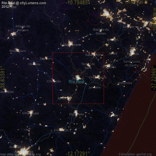
Analysis of Rio Real night lights 2016
Square area 10x10 km:
 1.73%
1.73%90-99
4.33%80-89
2.16%70-79
1.3%60-69
1.52%50-59
1.08%40-49
2.16%30-39
2.16%20-29
0.87%10-19
0.87%0-9
81.82%Square area 50x50 km:
0.38%90-99
0.78%80-89
0.44%70-79
0.52%60-69
0.81%50-59
1.05%40-49
0.76%30-39
0.89%20-29
0.73%10-19
3%0-9
90.63%Clear (daylight) street map image can be seen on geolist.org.
Map coordinates:
10° 47' 41.5" South, 38° 38' 9.3" West
11° 29' 5" South, 37° 55' 58" West
12° 10' 22.5" South, 37° 13' 46.8" West
Some cities around Rio Real sort by population:
• Tobias Barreto
34.2 km =21.3 mi,  347°
347°
• Esplanada
34.6 km =21.5 mi,  182°
182°
• Itabaianinha
28.1 km =17.5 mi,  33°
33°
• Boquim
50.7 km =31.5 mi,  42°
42°
• Acajutiba
21.8 km =13.5 mi,  204°
204°
• Umbaúba
32 km =19.9 mi,  69°
69°
• Olindina
45.6 km =28.3 mi,  286°
286°
• Cristinápolis
19.4 km =12.1 mi,  86°
86°
3451071 (p: 24,005)
Sources (retrieved 2019-11-25):
» Earth at Night: Flat Maps 2012, 2016