Poção de Pedras night lights from space
Night Light of Poção de Pedras (Maranhão) from space (Brazil) Src. Average luminocity for 10x10km area is 2.812% and for 50x50km: 1.6444%.
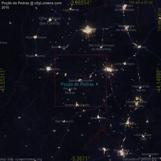
Analysis of Poção de Pedras night lights 2016
Square area 10x10 km:
 0%
0%90-99
0%80-89
0%70-79
0.83%60-69
0%50-59
1.65%40-49
1.45%30-39
0.21%20-29
0.83%10-19
0.21%0-9
94.83%Square area 50x50 km:
0.01%90-99
0.08%80-89
0.19%70-79
0.09%60-69
0.32%50-59
0.51%40-49
0.38%30-39
0.49%20-29
0.52%10-19
0.61%0-9
96.81%Clear (daylight) street map image can be seen on geolist.org.
Map coordinates:
3° 57' 55.9" South, 45° 33' 11.3" West
4° 40' 0" South, 44° 51' 0" West
5° 22' 1.6" South, 44° 8' 48.8" West
Some cities around Poção de Pedras sort by population:
• Bacabal
42.2 km =26.2 mi,  8°
8°
• Presidente Dutra
80 km =49.7 mi,  150°
150°
• São Mateus do Maranhão
81 km =50.3 mi,  30°
30°
• Lago da Pedra
60.3 km =37.5 mi,  314°
314°
• Tuntum
69.4 km =43.1 mi,  161°
161°
• Dom Pedro
61.5 km =38.2 mi,  132°
132°
• Esperantinópolis
27.2 km =16.9 mi,  144°
144°
• Paulo Ramos
62.2 km =38.6 mi,  323°
323°
3391774 (p: 12,337)
Sources (retrieved 2019-11-25):
» Earth at Night: Flat Maps 2012, 2016