Pirapemas night lights from space
Night Light of Pirapemas (Maranhão) from space (Brazil) Src. Average luminocity for 10x10km area is 6.9632% and for 50x50km: 0.6672%.
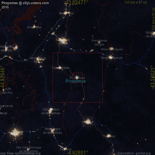
Analysis of Pirapemas night lights 2016
Square area 10x10 km:
 0.22%
0.22%90-99
0.87%80-89
1.52%70-79
1.73%60-69
0.87%50-59
0.22%40-49
1.95%30-39
0.43%20-29
1.73%10-19
0.87%0-9
89.61%Square area 50x50 km:
0.01%90-99
0.05%80-89
0.22%70-79
0.07%60-69
0.07%50-59
0.15%40-49
0.15%30-39
0.05%20-29
0.17%10-19
0.03%0-9
99.03%Clear (daylight) street map image can be seen on geolist.org.
Map coordinates:
3° 1' 29.2" South, 44° 55' 35.3" West
3° 43' 36" South, 44° 13' 24" West
4° 25' 40.8" South, 43° 31' 12.8" West
Some cities around Pirapemas sort by population:
• Itapecuru Mirim
40.1 km =24.9 mi,  337°
337°
• Coroatá
46.2 km =28.7 mi,  166°
166°
• São Mateus do Maranhão
44.8 km =27.8 mi,  218°
218°
• Vargem Grande
39.8 km =24.7 mi,  59°
59°
• Timbiras
66.6 km =41.4 mi,  151°
151°
• Santa Rita
43.1 km =26.8 mi,  110°
110°
• Cantanhede
19.9 km =12.4 mi,  301°
301°
• Anajatuba
67.7 km =42.1 mi,  319°
319°
3391940 (p: 6,439)
Sources (retrieved 2019-11-25):
» Earth at Night: Flat Maps 2012, 2016