Pedregulho night lights from space
Night Light of Pedregulho (São Paulo) from space (Brazil) Src. Average luminocity for 10x10km area is 5.9107% and for 50x50km: 2.0581%.
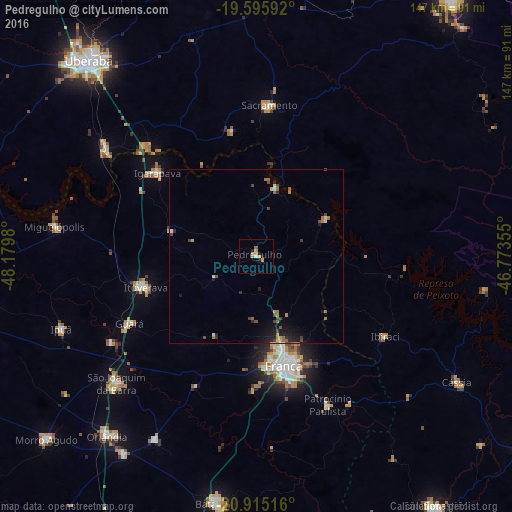
Analysis of Pedregulho night lights 2016
Square area 10x10 km:
 0%
0%90-99
0.79%80-89
0%70-79
3.17%60-69
1.59%50-59
0.79%40-49
0%30-39
0%20-29
1.19%10-19
1.19%0-9
91.27%Square area 50x50 km:
0.07%90-99
0.18%80-89
0.1%70-79
0.42%60-69
0.44%50-59
0.29%40-49
0.56%30-39
0.25%20-29
0.53%10-19
1.44%0-9
95.71%Clear (daylight) street map image can be seen on geolist.org.
Map coordinates:
19° 35' 45.3" South, 48° 10' 47.3" West
20° 15' 25" South, 47° 28' 36" West
20° 54' 54.6" South, 46° 46' 24.8" West
Some cities around Pedregulho sort by population:
• Franca
32.3 km =20.1 mi,  165°
165°
• São Joaquim da Barra
53.4 km =33.2 mi,  227°
227°
• Ituverava
33 km =20.5 mi,  253°
253°
• Igarapava
37.2 km =23.1 mi,  310°
310°
• Guará
40.9 km =25.4 mi,  242°
242°
• Miguelópolis
58.6 km =36.4 mi,  278°
278°
• Sacramento
43.7 km =27.2 mi,  5°
5°
• Ipuã
59.4 km =36.9 mi, 250°
3454408 (p: 11,216)
Sources (retrieved 2019-11-25):
» Earth at Night: Flat Maps 2012, 2016