Miguelópolis night lights from space
Night Light of Miguelópolis (São Paulo) from space (Brazil) Src. Average luminocity for 10x10km area is 10.1885% and for 50x50km: 2.0751%.
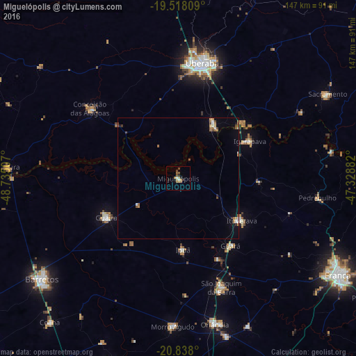
Analysis of Miguelópolis night lights 2016
Square area 10x10 km:
 0.79%
0.79%90-99
0.79%80-89
1.19%70-79
1.59%60-69
2.78%50-59
2.18%40-49
1.79%30-39
0%20-29
2.58%10-19
1.39%0-9
84.92%Square area 50x50 km:
0.22%90-99
0.23%80-89
0.08%70-79
0.36%60-69
0.5%50-59
0.33%40-49
0.28%30-39
0.09%20-29
0.25%10-19
0.39%0-9
97.27%Clear (daylight) street map image can be seen on geolist.org.
Map coordinates:
19° 31' 5.1" South, 48° 44' 6.3" West
20° 10' 46" South, 48° 1' 55" West
20° 50' 16.8" South, 47° 19' 43.8" West
Some cities around Miguelópolis sort by population:
• Uberaba
49.1 km =30.5 mi,  12°
12°
• São Joaquim da Barra
48.4 km =30.1 mi,  157°
157°
• Ituverava
31.7 km =19.7 mi,  124°
124°
• Guaíra
32.9 km =20.4 mi,  242°
242°
• Igarapava
33.6 km =20.9 mi,  62°
62°
• Guará
35.1 km =21.8 mi,  141°
141°
• Conceição das Alagoas
47.5 km =29.5 mi,  308°
308°
• Ipuã
28.8 km =17.9 mi,  175°
175°
3457192 (p: 18,262)
Sources (retrieved 2019-11-25):
» Earth at Night: Flat Maps 2012, 2016