Pariquera Açu night lights from space
Night Light of Pariquera Açu (São Paulo) from space (Brazil) Src. Average luminocity for 10x10km area is 8.1786% and for 50x50km: 2.5379%.
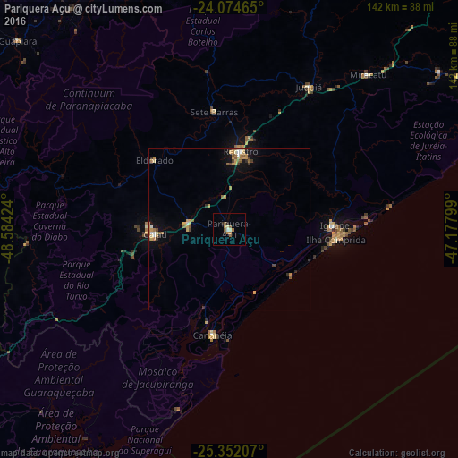
Analysis of Pariquera Açu night lights 2016
Square area 10x10 km:
 0.6%
0.6%90-99
0.79%80-89
0.99%70-79
1.19%60-69
1.98%50-59
3.17%40-49
0%30-39
0%20-29
1.79%10-19
0.6%0-9
88.89%Square area 50x50 km:
0.17%90-99
0.23%80-89
0.4%70-79
0.56%60-69
0.53%50-59
0.51%40-49
0.13%30-39
0.3%20-29
0.23%10-19
1%0-9
95.94%Clear (daylight) street map image can be seen on geolist.org.
Map coordinates:
24° 4' 28.7" South, 48° 35' 3.3" West
24° 42' 54" South, 47° 52' 52" West
25° 21' 7.5" South, 47° 10' 40.8" West
Some cities around Pariquera Açu sort by population:
• Registro
25.6 km =15.9 mi,  8°
8°
• Capâo Bonito
92 km =57.2 mi,  328°
328°
• Cajati
24.5 km =15.2 mi,  264°
264°
• Iguape
32.9 km =20.4 mi,  88°
88°
• Cananéia
33.6 km =20.9 mi,  187°
187°
• Juquiá
50.4 km =31.3 mi,  29°
29°
• Miracatu
64.4 km =40 mi,  41°
41°
• Jacupiranga
12.5 km =7.8 mi,  281°
281°
3454967 (p: 13,436)
Sources (retrieved 2019-11-25):
» Earth at Night: Flat Maps 2012, 2016