Paraíso night lights from space
Night Light of Paraíso (São Paulo) from space (Brazil) Src. Average luminocity for 10x10km area is 100% and for 50x50km: 84.6048%.
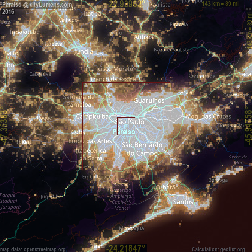
Analysis of Paraíso night lights 2016
Square area 10x10 km:
 100%
100%90-99
0%80-89
0%70-79
0%60-69
0%50-59
0%40-49
0%30-39
0%20-29
0%10-19
0%0-9
0%Square area 50x50 km:
48.42%90-99
13.38%80-89
5.16%70-79
8.01%60-69
9.17%50-59
6.52%40-49
4.55%30-39
2.05%20-29
2.07%10-19
0.67%0-9
0%Clear (daylight) street map image can be seen on geolist.org.
Map coordinates:
22° 55' 46.6" South, 47° 21' 13.8" West
23° 34' 32.3" South, 46° 39' 2.5" West
24° 13' 6.5" South, 45° 56' 51.3" West
Some cities around Paraíso sort by population:
• São Paulo
3.5 km =2.2 mi,  25°
25°
• São Bernardo do Campo
15.8 km =9.8 mi,  146°
146°
• Osasco
15.1 km =9.4 mi,  288°
288°
• Santo André
15.1 km =9.4 mi,  130°
130°
• Diadema
12.6 km =7.8 mi,  166°
166°
• Taboão da Serra
15.4 km =9.6 mi,  248°
248°
• São Caetano do Sul
11.4 km =7.1 mi,  117°
117°
• Jardim Paulista
1.7 km =1.1 mi,  305°
305°
11962196 (p: 6,290)
Sources (retrieved 2019-11-25):
» Earth at Night: Flat Maps 2012, 2016