Natividade night lights from space
Night Light of Natividade (Rio de Janeiro) from space (Brazil) Src. Average luminocity for 10x10km area is 9.7321% and for 50x50km: 3.4082%.
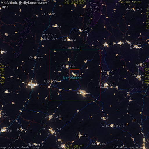
Analysis of Natividade night lights 2016
Square area 10x10 km:
 0.4%
0.4%90-99
0.4%80-89
2.58%70-79
4.56%60-69
0%50-59
0.79%40-49
0%30-39
0.79%20-29
2.38%10-19
0.6%0-9
87.5%Square area 50x50 km:
0.19%90-99
0.2%80-89
0.51%70-79
1.23%60-69
0.5%50-59
0.25%40-49
0.48%30-39
0.45%20-29
0.34%10-19
1.17%0-9
94.69%Clear (daylight) street map image can be seen on geolist.org.
Map coordinates:
20° 23' 4.4" South, 42° 40' 35.3" West
21° 2' 32" South, 41° 58' 24" West
21° 41' 49.2" South, 41° 16' 12.8" West
Some cities around Natividade sort by population:
• Muriaé
41.9 km =26 mi,  256°
256°
• Itaperuna
20.2 km =12.6 mi,  153°
153°
• Bom Jesus do Itabapoana
32.1 km =19.9 mi,  108°
108°
• Carangola
34.9 km =21.7 mi,  350°
350°
• Guaçuí
42.6 km =26.5 mi,  45°
45°
• Espera Feliz
44.1 km =27.4 mi,  8°
8°
• Porciúncula
11.3 km =7 mi,  321°
321°
• São José do Calçado
33.1 km =20.6 mi,  86°
86°
3456377 (p: 12,014)
Sources (retrieved 2019-11-25):
» Earth at Night: Flat Maps 2012, 2016