Mutuípe night lights from space
Night Light of Mutuípe (Bahia) from space (Brazil) Src. Average luminocity for 10x10km area is 4.7511% and for 50x50km: 1.6733%.
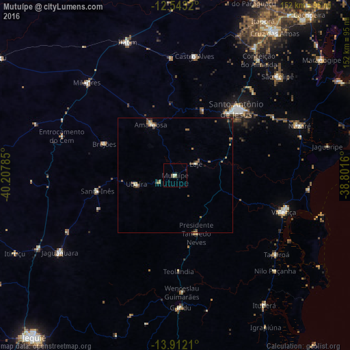
Analysis of Mutuípe night lights 2016
Square area 10x10 km:
 0%
0%90-99
1.52%80-89
1.08%70-79
0%60-69
0%50-59
1.52%40-49
0.22%30-39
0.87%20-29
0.43%10-19
0.87%0-9
93.51%Square area 50x50 km:
0%90-99
0.25%80-89
0.24%70-79
0.21%60-69
0.33%50-59
0.49%40-49
0.25%30-39
0.18%20-29
0.29%10-19
0.43%0-9
97.34%Clear (daylight) street map image can be seen on geolist.org.
Map coordinates:
12° 32' 35.5" South, 40° 12' 28.3" West
13° 13' 43" South, 39° 30' 17" West
13° 54' 43.6" South, 38° 48' 5.8" West
Some cities around Mutuípe sort by population:
• Santo Antônio de Jesus
39.1 km =24.3 mi,  42°
42°
• Valença
49.3 km =30.6 mi,  108°
108°
• Amargosa
24.6 km =15.3 mi,  333°
333°
• Muritiba
44.3 km =27.5 mi, 38°
• Castro Alves
52.1 km =32.4 mi,  9°
9°
• Santa Inês
34.7 km =21.6 mi,  258°
258°
• Taperoá
55.8 km =34.7 mi,  128°
128°
• Ubaíra
17.7 km =11 mi, 255°
3456450 (p: 10,016)
Sources (retrieved 2019-11-25):
» Earth at Night: Flat Maps 2012, 2016