Mirante do Paranapanema night lights from space
Night Light of Mirante do Paranapanema (São Paulo) from space (Brazil) Src. Average luminocity for 10x10km area is 5.0265% and for 50x50km: 0.5759%.
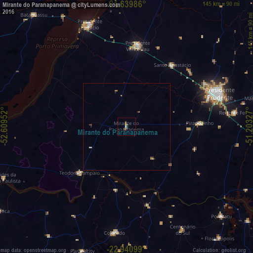
Analysis of Mirante do Paranapanema night lights 2016
Square area 10x10 km:
 0%
0%90-99
0.76%80-89
0%70-79
1.52%60-69
0.76%50-59
0%40-49
2.46%30-39
1.7%20-29
1.14%10-19
0%0-9
91.67%Square area 50x50 km:
0.03%90-99
0.06%80-89
0.03%70-79
0.1%60-69
0.19%50-59
0%40-49
0.22%30-39
0.12%20-29
0.18%10-19
0.01%0-9
99.06%Clear (daylight) street map image can be seen on geolist.org.
Map coordinates:
21° 38' 23.5" South, 52° 36' 34.3" West
22° 17' 31" South, 51° 54' 23" West
22° 56' 27.6" South, 51° 12' 11.8" West
Some cities around Mirante do Paranapanema sort by population:
• Presidente Prudente
56.4 km =35 mi,  70°
70°
• Presidente Venceslau
46.7 km =29 mi,  7°
7°
• Pirapozinho
41.9 km =26 mi,  87°
87°
• Álvares Machado
50.6 km =31.4 mi,  62°
62°
• Colorado
61 km =37.9 mi,  186°
186°
• Santo Anastácio
58.9 km =36.6 mi,  31°
31°
• Teodoro Sampaio
37.9 km =23.5 mi,  225°
225°
• Presidente Bernardes
48.3 km =30 mi,  48°
48°
3457098 (p: 9,387)
Sources (retrieved 2019-11-25):
» Earth at Night: Flat Maps 2012, 2016