Itiruçu night lights from space
Night Light of Itiruçu (Bahia) from space (Brazil) Src. Average luminocity for 10x10km area is 3.907% and for 50x50km: 1.3325%.
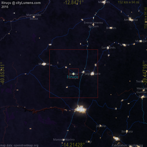
Analysis of Itiruçu night lights 2016
Square area 10x10 km:
100  0%
0%
90-99 0.83%
80-89 0.83%
70-79 1.03%
60-69 1.45%
50-59 0%
40-49 0%
30-39 0%
20-29 0%
10-19 0%
0-9 95.87%
0%90-99
0.83%80-89
0.83%70-79
1.03%60-69
1.45%50-59
0%40-49
0%30-39
0%20-29
0%10-19
0%0-9
95.87%Square area 50x50 km:
100 0.07%
90-99 0.27%
80-89 0.18%
70-79 0.13%
60-69 0.16%
50-59 0.34%
40-49 0.16%
30-39 0.09%
20-29 0.18%
10-19 0.26%
0-9 98.15%
0.07%90-99
0.27%80-89
0.18%70-79
0.13%60-69
0.16%50-59
0.34%40-49
0.16%30-39
0.09%20-29
0.18%10-19
0.26%0-9
98.15%Clear (daylight) street map image can be seen on geolist.org.
Map coordinates:
12° 50' 49.6" South, 40° 51' 12.3" West
13° 31' 54" South, 40° 9' 1" West
14° 12' 51.4" South, 39° 26' 49.8" West
Some cities around Itiruçu sort by population:
• Jequié
37 km =23 mi,  169°
169°
• Jaguaquara
19.4 km =12.1 mi,  89°
89°
• Maracás
32 km =19.9 mi,  288°
288°
• Gandu
75.5 km =46.9 mi,  108°
108°
• Jitaúna
60 km =37.3 mi,  153°
153°
• Itagi
71.9 km =44.7 mi, 167°
• Santa Inês
44.6 km =27.7 mi,  53°
53°
• Ubaíra
60.3 km =37.5 mi,  60°
60°
3460549 (p: 11,498)
Sources (retrieved 2019-11-25):
» Earth at Night: Flat Maps 2012, 2016