Itatiaia night lights from space
Night Light of Itatiaia (Rio de Janeiro) from space (Brazil) Src. Average luminocity for 10x10km area is 24.1686% and for 50x50km: 5.7031%.
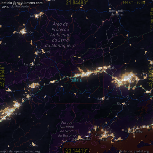
Analysis of Itatiaia night lights 2016
Square area 10x10 km:
 1.14%
1.14%90-99
1.14%80-89
3.6%70-79
3.98%60-69
4.36%50-59
2.84%40-49
6.44%30-39
4.92%20-29
6.25%10-19
25.19%0-9
40.15%Square area 50x50 km:
0.39%90-99
0.6%80-89
0.58%70-79
1.1%60-69
0.94%50-59
0.89%40-49
0.91%30-39
0.83%20-29
1.33%10-19
5.62%0-9
86.8%Clear (daylight) street map image can be seen on geolist.org.
Map coordinates:
21° 50' 41.9" South, 45° 15' 59.3" West
22° 29' 46" South, 44° 33' 48" West
23° 8' 39.1" South, 43° 51' 36.8" West
Some cities around Itatiaia sort by population:
• Volta Redonda
47.3 km =29.4 mi,  93°
93°
• Barra Mansa
40.6 km =25.2 mi,  97°
97°
• Resende
12.4 km =7.7 mi,  75°
75°
• Cruzeiro
42.7 km =26.5 mi,  258°
258°
• Passa Quatro
43.1 km =26.8 mi,  285°
285°
• Porto Real
29.3 km =18.2 mi,  73°
73°
• Itanhandu
44.2 km =27.5 mi,  300°
300°
• Quatis
32.9 km =20.4 mi, 72°
3460602 (p: 12,571)
Sources (retrieved 2019-11-25):
» Earth at Night: Flat Maps 2012, 2016