Inhambupe night lights from space
Night Light of Inhambupe (Bahia) from space (Brazil) Src. Average luminocity for 10x10km area is 16.4855% and for 50x50km: 1.9056%.
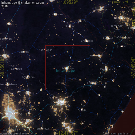
Analysis of Inhambupe night lights 2016
Square area 10x10 km:
 2.48%
2.48%90-99
2.48%80-89
0.83%70-79
2.07%60-69
2.07%50-59
2.89%40-49
2.48%30-39
2.89%20-29
2.48%10-19
3.1%0-9
76.24%Square area 50x50 km:
0.11%90-99
0.16%80-89
0.13%70-79
0.19%60-69
0.24%50-59
0.46%40-49
0.51%30-39
0.5%20-29
0.53%10-19
0.46%0-9
96.72%Clear (daylight) street map image can be seen on geolist.org.
Map coordinates:
11° 5' 43" South, 39° 3' 22.3" West
11° 47' 4" South, 38° 21' 11" West
12° 28' 18.7" South, 37° 38' 59.8" West
Some cities around Inhambupe sort by population:
• Alagoinhas
39.7 km =24.7 mi,  190°
190°
• Entre Rios
34.1 km =21.2 mi,  120°
120°
• Rio Real
56.6 km =35.2 mi,  53°
53°
• Esplanada
44.4 km =27.6 mi,  91°
91°
• Acajutiba
39 km =24.2 mi,  69°
69°
• Olindina
46.5 km =28.9 mi,  2°
2°
• Nova Soure
62.9 km =39.1 mi,  346°
346°
• Irará
53.8 km =33.4 mi,  236°
236°
3461224 (p: 14,735)
Sources (retrieved 2019-11-25):
» Earth at Night: Flat Maps 2012, 2016