Igaraçu do Tietê night lights from space
Night Light of Igaraçu do Tietê (São Paulo) from space (Brazil) Src. Average luminocity for 10x10km area is 34.5663% and for 50x50km: 9.1837%.
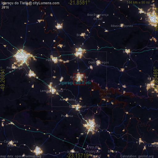

Analysis of Igaraçu do Tietê night lights 2016
Square area 10x10 km:
 3.6%
3.6%90-99
5.68%80-89
4.73%70-79
4.17%60-69
8.14%50-59
3.6%40-49
4.92%30-39
7.01%20-29
3.79%10-19
29.92%0-9
24.43%Square area 50x50 km:
0.92%90-99
1.03%80-89
1.03%70-79
1.61%60-69
1.29%50-59
0.73%40-49
1.52%30-39
1.48%20-29
1.34%10-19
7.46%0-9
81.59%Clear (daylight) street map image can be seen on geolist.org.
Map coordinates:
21° 51' 29.2" South, 49° 15' 39.3" West
22° 30' 33" South, 48° 33' 28" West
23° 9' 25.9" South, 47° 51' 16.8" West
Some cities around Igaraçu do Tietê sort by population:
• Jaú
23.7 km =14.7 mi,  0°
0°
• Lençóis Paulista
26.8 km =16.7 mi,  248°
248°
• Pederneiras
28.4 km =17.6 mi,  308°
308°
• Barra Bonita
1.6 km =1 mi,  358°
358°
• São Manuel
24.7 km =15.3 mi,  183°
183°
• Dois Córregos
24.2 km =15 mi,  48°
48°
• Macatuba
15.8 km =9.8 mi,  272°
272°
• Itapuí
34.9 km =21.7 mi,  331°
331°
3461501 (p: 22,758)
Sources (retrieved 2019-11-25):
» Earth at Night: Flat Maps 2012, 2016