Governador Dix Sept Rosado night lights from space
Night Light of Governador Dix Sept Rosado (Rio Grande do Norte) from space (Brazil) Src. Average luminocity for 10x10km area is 7.0537% and for 50x50km: 1.7539%.
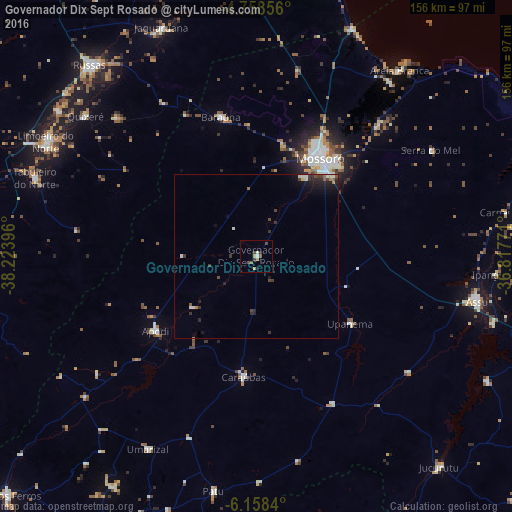
Analysis of Governador Dix Sept Rosado night lights 2016
Square area 10x10 km:
 0.41%
0.41%90-99
1.03%80-89
0.41%70-79
2.27%60-69
0%50-59
1.45%40-49
2.69%30-39
0.83%20-29
0.83%10-19
0.83%0-9
89.26%Square area 50x50 km:
0.1%90-99
0.35%80-89
0.14%70-79
0.11%60-69
0.14%50-59
0.26%40-49
0.39%30-39
0.47%20-29
0.7%10-19
1.1%0-9
96.24%Clear (daylight) street map image can be seen on geolist.org.
Map coordinates:
4° 45' 30.8" South, 38° 13' 26.3" West
5° 27' 32" South, 37° 31' 15" West
6° 9' 30.2" South, 36° 49' 3.8" West
Some cities around Governador Dix Sept Rosado sort by population:
• Mossoró
36 km =22.4 mi,  32°
32°
• Açu
69 km =42.9 mi,  100°
100°
• Apodi
38.3 km =23.8 mi,  233°
233°
• Baraúna
43.4 km =27 mi,  345°
345°
• Caraúbas
37.3 km =23.2 mi,  186°
186°
• Quixeré
67.2 km =41.8 mi,  309°
309°
• Umarizal
67.5 km =41.9 mi,  208°
208°
• Upanema
35.5 km =22.1 mi,  124°
124°
3398871 (p: 6,626)
Sources (retrieved 2019-11-25):
» Earth at Night: Flat Maps 2012, 2016