Freguesia do Ribeirao da Ilha night lights from space
Night Light of Freguesia do Ribeirao da Ilha (Santa Catarina) from space (Brazil) Src. Average luminocity for 10x10km area is 28.0139% and for 50x50km: 21.5462%.
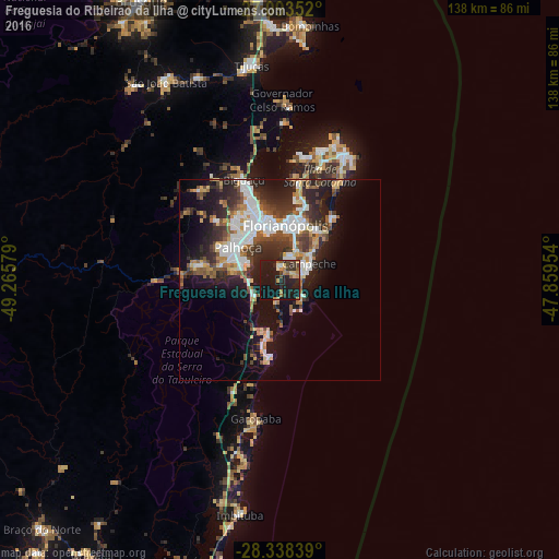

Analysis of Freguesia do Ribeirao da Ilha night lights 2016
Square area 10x10 km:
 0.4%
0.4%90-99
1.98%80-89
3.97%70-79
3.97%60-69
5.16%50-59
2.98%40-49
4.17%30-39
4.56%20-29
13.89%10-19
55.95%0-9
2.98%Square area 50x50 km:
4.24%90-99
4.15%80-89
1.83%70-79
2.16%60-69
2.14%50-59
2.92%40-49
3.25%30-39
3.86%20-29
6.99%10-19
13.37%0-9
55.1%Clear (daylight) street map image can be seen on geolist.org.
Map coordinates:
27° 5' 36.7" South, 49° 15' 56.8" West
27° 43' 3.8" South, 48° 33' 45.6" West
28° 20' 18.2" South, 47° 51' 34.3" West
Some cities around Freguesia do Ribeirao da Ilha sort by population:
• Florianópolis
13.5 km =8.4 mi,  5°
5°
• Palhoça
13.1 km =8.1 mi,  307°
307°
• Ribeirão da Ilha
3.6 km =2.2 mi,  55°
55°
• Campinas
14.4 km =8.9 mi,  342°
342°
• Trindade
15.1 km =9.4 mi, 14°
• Saco dos Limoes
12.4 km =7.7 mi, 12°
• Costeira do Pirajubae
10 km =6.2 mi,  24°
24°
• Santa Monica
15.1 km =9.4 mi, 21°
7874492 (p: 21,000)
Sources (retrieved 2019-11-25):
» Earth at Night: Flat Maps 2012, 2016