Descalvado night lights from space
Night Light of Descalvado (São Paulo) from space (Brazil) Src. Average luminocity for 10x10km area is 24.0774% and for 50x50km: 7.0073%.

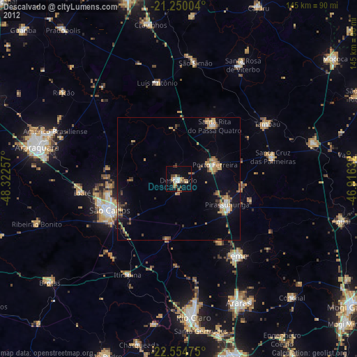
Analysis of Descalvado night lights 2016
Square area 10x10 km:
 3.37%
3.37%90-99
2.58%80-89
2.18%70-79
7.74%60-69
1.98%50-59
1.59%40-49
3.77%30-39
1.98%20-29
1.39%10-19
23.21%0-9
50.2%Square area 50x50 km:
0.53%90-99
0.44%80-89
0.83%70-79
1.47%60-69
1.07%50-59
0.93%40-49
1%30-39
0.91%20-29
1.23%10-19
6.38%0-9
85.2%Clear (daylight) street map image can be seen on geolist.org.
Map coordinates:
21° 15' 0.1" South, 48° 19' 21.3" West
21° 54' 14" South, 47° 37' 10" West
22° 33' 17.1" South, 46° 54' 58.8" West
Some cities around Descalvado sort by population:
• São Carlos
30.7 km =19.1 mi,  245°
245°
• Leme
39.2 km =24.4 mi,  142°
142°
• Pirassununga
22.4 km =13.9 mi,  117°
117°
• Porto Ferreira
15.5 km =9.6 mi,  68°
68°
• Ibaté
39.3 km =24.4 mi,  261°
261°
• Santa Cruz das Palmeiras
39.2 km =24.4 mi,  77°
77°
• Santa Rita do Passa Quatro
26 km =16.2 mi,  34°
34°
• Tambaú
41.9 km =26 mi,  58°
58°
3464809 (p: 26,137)
Sources (retrieved 2019-11-25):
» Earth at Night: Flat Maps 2012, 2016