Demerval Lobão night lights from space
Night Light of Demerval Lobão (Piauí) from space (Brazil) Src. Average luminocity for 10x10km area is 9.2913% and for 50x50km: 7.0868%.
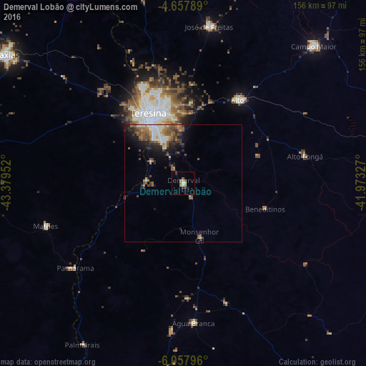
Analysis of Demerval Lobão night lights 2016
Square area 10x10 km:
 0.62%
0.62%90-99
1.03%80-89
0.83%70-79
2.07%60-69
1.65%50-59
1.65%40-49
0.83%30-39
2.07%20-29
0.83%10-19
0%0-9
88.43%Square area 50x50 km:
0.73%90-99
1.37%80-89
0.51%70-79
0.59%60-69
1.4%50-59
1.71%40-49
1.25%30-39
1.17%20-29
1.65%10-19
3.16%0-9
86.45%Clear (daylight) street map image can be seen on geolist.org.
Map coordinates:
4° 39' 28.4" South, 43° 22' 46.3" West
5° 21' 30" South, 42° 40' 35" West
6° 3' 28.7" South, 41° 58' 23.8" West
Some cities around Demerval Lobão sort by population:
• Teresina
33 km =20.5 mi,  335°
335°
• Timon
34.3 km =21.3 mi,  328°
328°
• Altos
42.9 km =26.7 mi,  33°
33°
• José de Freitas
67.9 km =42.2 mi,  9°
9°
• Água Branca
59.5 km =37 mi,  175°
175°
• Parnarama
58.5 km =36.4 mi,  232°
232°
• São Pedro do Piauí
63.7 km =39.6 mi, 184°
• Beneditinos
35.8 km =22.2 mi,  106°
106°
3401106 (p: 15,265)
Sources (retrieved 2019-11-25):
» Earth at Night: Flat Maps 2012, 2016