Sitrah night lights from space
Night Light of Sitrah (Manama) from space (Bahrain) Src. Average luminocity for 10x10km area is 90.0853% and for 50x50km: 38.1168%.
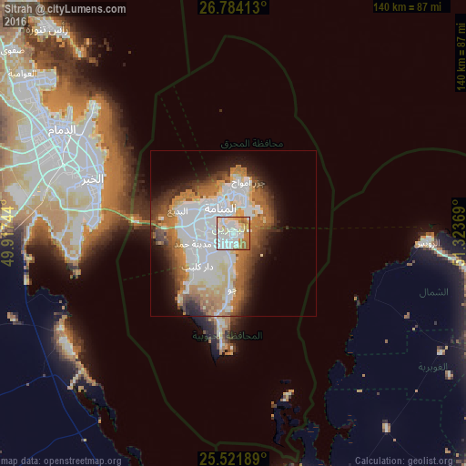

Analysis of Sitrah night lights 2016
Square area 10x10 km:
 35.91%
90-99
31.35%80-89
9.52%70-79
7.74%60-69
13.69%50-59
1.79%40-49
0%30-39
0%20-29
0%10-19
0%0-9
0%Square area 50x50 km:
11.86%90-99
8.37%80-89
3.63%70-79
3.58%60-69
6.99%50-59
4.22%40-49
3.62%30-39
4.28%20-29
4.28%10-19
6.86%0-9
42.29%Clear (daylight) street map image can be seen on geolist.org.
Map coordinates:
26° 47' 2.9" North, 49° 55' 2.8" East
26° 9' 17" North, 50° 37' 14" East
25° 31' 18.8" North, 51° 19' 25.3" East
Some cities around Sitrah sort by population:
• Manama
8.8 km =5.5 mi,  336°
336°
• Al Muharraq
11.4 km =7.1 mi,  355°
355°
• Ar Rifā‘
7.1 km =4.4 mi,  247°
247°
• Dār Kulayb
15.1 km =9.4 mi,  230°
230°
• Madīnat Ḩamad
12.2 km =7.6 mi, 248°
• Madīnat ‘Īsá
7.6 km =4.7 mi,  286°
286°
• Jidd Ḩafş
10.2 km =6.3 mi,  314°
314°
• Al Ḩadd
10.6 km =6.6 mi,  18°
18°
290104 (p: 37,657)
Sources (retrieved 2019-11-25):
» Earth at Night: Flat Maps 2012, 2016