Yakoruda night lights from space
Night Light of Yakoruda (Blagoevgrad) from space (Bulgaria) Src. Average luminocity for 10x10km area is 1.027% and for 50x50km: 0.8937%.
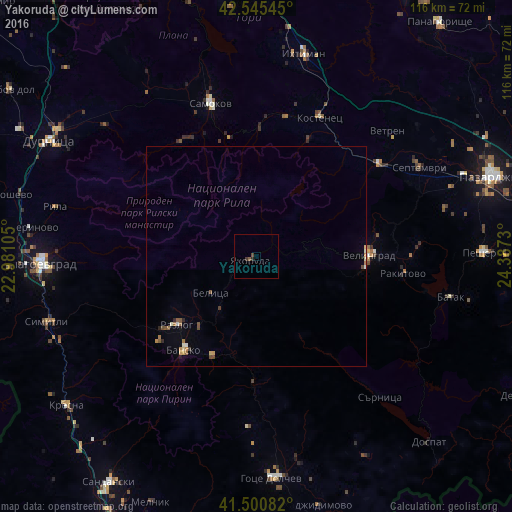
Analysis of Yakoruda night lights 2016
Square area 10x10 km:
 0%
0%90-99
0%80-89
0%70-79
0%60-69
0%50-59
0.63%40-49
0.63%30-39
0.63%20-29
0.63%10-19
0%0-9
97.46%Square area 50x50 km:
0.02%90-99
0.15%80-89
0.08%70-79
0.13%60-69
0.15%50-59
0.23%40-49
0.18%30-39
0.07%20-29
0.13%10-19
0.05%0-9
98.82%Clear (daylight) street map image can be seen on geolist.org.
Map coordinates:
42° 32' 43.6" North, 22° 58' 51.8" East
42° 1' 31" North, 23° 41' 3" East
41° 30' 3" North, 24° 23' 14.3" East
Some cities around Yakoruda sort by population:
• Blagoevgrad
48.3 km =30 mi,  268°
268°
• Samokov
36.3 km =22.6 mi,  342°
342°
• Velingrad
25.4 km =15.8 mi,  89°
89°
• Ihtiman
46.7 km =29 mi,  13°
13°
• Razlog
23.7 km =14.7 mi,  229°
229°
• Bansko
26.3 km =16.3 mi,  217°
217°
• Septemvri
42.2 km =26.2 mi,  60°
60°
• Rakitovo
33.5 km =20.8 mi,  96°
96°
725586 (p: 6,008)
Sources (retrieved 2019-11-25):
» Earth at Night: Flat Maps 2012, 2016