Peshtera night lights from space
Night Light of Peshtera (Pazardzhik) from space (Bulgaria) Src. Average luminocity for 10x10km area is 6.6254% and for 50x50km: 3.6252%.
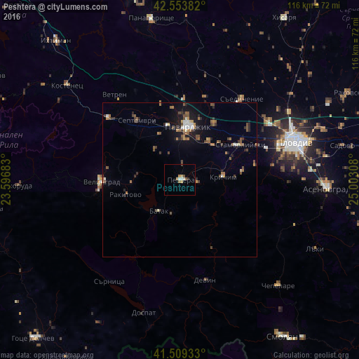
Analysis of Peshtera night lights 2016
Square area 10x10 km:
 1.11%
1.11%90-99
0.79%80-89
0.63%70-79
1.9%60-69
0.63%50-59
1.27%40-49
0%30-39
0.32%20-29
0.63%10-19
0%0-9
92.7%Square area 50x50 km:
0.26%90-99
0.38%80-89
0.18%70-79
0.44%60-69
0.68%50-59
0.74%40-49
0.75%30-39
0.55%20-29
0.72%10-19
2.24%0-9
93.07%Clear (daylight) street map image can be seen on geolist.org.
Map coordinates:
42° 33' 13.8" North, 23° 35' 48.6" East
42° 2' 1.4" North, 24° 17' 59.8" East
41° 30' 33.6" North, 25° 0' 11.1" East
Some cities around Peshtera sort by population:
• Pazardzhik
18.7 km =11.6 mi,  8°
8°
• Velingrad
25.5 km =15.8 mi,  268°
268°
• Stamboliyski
22.2 km =13.8 mi,  60°
60°
• Septemvri
24.2 km =15 mi,  324°
324°
• Krichim
13.9 km =8.6 mi,  82°
82°
• Rakitovo
18.2 km =11.3 mi,  254°
254°
• Saedinenie
33.1 km =20.6 mi,  38°
38°
• Perushtitsa
20.7 km =12.9 mi, 84°
728317 (p: 18,676)
Sources (retrieved 2019-11-25):
» Earth at Night: Flat Maps 2012, 2016