Slivnitsa night lights from space
Night Light of Slivnitsa (Sofia) from space (Bulgaria) Src. Average luminocity for 10x10km area is 3.2651% and for 50x50km: 8.4441%.
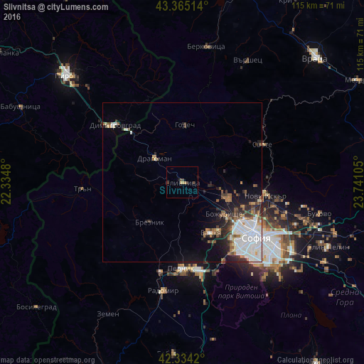
Analysis of Slivnitsa night lights 2016
Square area 10x10 km:
 0%
0%90-99
0%80-89
0%70-79
1.11%60-69
0.79%50-59
0%40-49
1.9%30-39
1.27%20-29
0%10-19
0.95%0-9
93.97%Square area 50x50 km:
2.49%90-99
2.01%80-89
0.31%70-79
0.49%60-69
0.88%50-59
1.23%40-49
0.82%30-39
0.95%20-29
1.92%10-19
3.26%0-9
85.63%Clear (daylight) street map image can be seen on geolist.org.
Map coordinates:
43° 21' 54.5" North, 22° 20' 5.3" East
42° 51' 6.6" North, 23° 2' 16.5" East
42° 20' 3.1" North, 23° 44' 27.8" East
Some cities around Slivnitsa sort by population:
• Sofia
29 km =18 mi,  126°
126°
• Pernik
28 km =17.4 mi,  180°
180°
• Berkovitsa
43.3 km =26.9 mi,  9°
9°
• Radomir
34.6 km =21.5 mi,  189°
189°
• Kostinbrod
15.1 km =9.4 mi,  105°
105°
• Svoge
28.4 km =17.6 mi,  63°
63°
• Varshets
43 km =26.7 mi,  28°
28°
• Godech
18.4 km =11.4 mi,  2°
2°
727069 (p: 7,545)
Sources (retrieved 2019-11-25):
» Earth at Night: Flat Maps 2012, 2016