Zonnebeke night lights from space
Night Light of Zonnebeke (Flanders) from space (Belgium) Src. Average luminocity for 10x10km area is 12.6877% and for 50x50km: 32.057%.
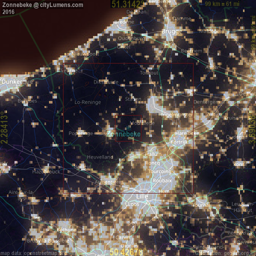
Analysis of Zonnebeke night lights 2016
Square area 10x10 km:
 0%
0%90-99
0.28%80-89
0.84%70-79
0.42%60-69
0.28%50-59
3.22%40-49
3.92%30-39
2.24%20-29
3.92%10-19
21.29%0-9
63.59%Square area 50x50 km:
7.48%90-99
5.87%80-89
2.9%70-79
3.41%60-69
4.12%50-59
4.35%40-49
4.21%30-39
5.49%20-29
8.48%10-19
13.18%0-9
40.51%Clear (daylight) street map image can be seen on geolist.org.
Map coordinates:
51° 18' 51.1" North, 2° 17' 2.9" East
50° 52' 21.4" North, 2° 59' 14.1" East
50° 25' 36.4" North, 3° 41' 25.4" East
Some cities around Zonnebeke sort by population:
• Roeselare
12.6 km =7.8 mi,  49°
49°
• Ieper
7.5 km =4.7 mi,  251°
251°
• Wervik
10.8 km =6.7 mi,  160°
160°
• Comines, FR
12.5 km =7.8 mi,  172°
172°
• Staden
11.5 km =7.1 mi,  9°
9°
• Moorslede
5.6 km =3.5 mi,  67°
67°
• Ledegem
9.7 km =6 mi,  99°
99°
• Houthulst
12 km =7.5 mi,  347°
347°
2783184 (p: 11,581)
Sources (retrieved 2019-11-25):
» Earth at Night: Flat Maps 2012, 2016