Laarne night lights from space
Night Light of Laarne (Flanders) from space (Belgium) Src. Average luminocity for 10x10km area is 58.8717% and for 50x50km: 43.2215%.
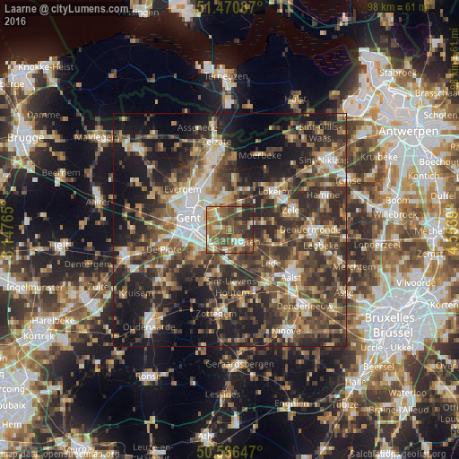
Analysis of Laarne night lights 2016
Square area 10x10 km:
 4.55%
4.55%90-99
9.09%80-89
5.21%70-79
8.69%60-69
19.79%50-59
15.64%40-49
17.78%30-39
8.56%20-29
10.7%10-19
0%0-9
0%Square area 50x50 km:
4.84%90-99
6.23%80-89
4.45%70-79
5.29%60-69
6.96%50-59
8.6%40-49
11.27%30-39
10.63%20-29
16.46%10-19
17.09%0-9
8.19%Clear (daylight) street map image can be seen on geolist.org.
Map coordinates:
51° 28' 15.1" North, 3° 8' 51.5" East
51° 1' 50.8" North, 3° 51' 2.8" East
50° 35' 11.3" North, 4° 33' 14" East
Some cities around Laarne sort by population:
• Wetteren
3.6 km =2.2 mi,  141°
141°
• Merelbeke
8.4 km =5.2 mi,  241°
241°
• Lochristi
7.4 km =4.6 mi,  349°
349°
• Destelbergen
4.8 km =3 mi,  311°
311°
• Oosterzele
9.4 km =5.8 mi,  202°
202°
• Wichelen
9.3 km =5.8 mi,  107°
107°
• Melle
4.5 km =2.8 mi,  225°
225°
• Ledeberg
7.5 km =4.7 mi,  276°
276°
2793797 (p: 11,600)
Sources (retrieved 2019-11-25):
» Earth at Night: Flat Maps 2012, 2016