Kruishoutem night lights from space
Night Light of Kruishoutem (Flanders) from space (Belgium) Src. Average luminocity for 10x10km area is 31.1106% and for 50x50km: 38.6025%.
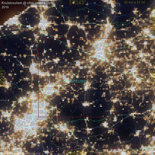
Analysis of Kruishoutem night lights 2016
Square area 10x10 km:
100  1.96%
1.96%
90-99 1.96%
80-89 0.98%
70-79 2.94%
60-69 4.48%
50-59 8.96%
40-49 4.34%
30-39 7%
20-29 30.11%
10-19 36.55%
0-9 0.7%
1.96%90-99
1.96%80-89
0.98%70-79
2.94%60-69
4.48%50-59
8.96%40-49
4.34%30-39
7%20-29
30.11%10-19
36.55%0-9
0.7%Square area 50x50 km:
100 6.45%
90-99 6.52%
80-89 3.81%
70-79 4.54%
60-69 5.64%
50-59 7.21%
40-49 6.45%
30-39 6.67%
20-29 11.78%
10-19 19.49%
0-9 21.42%
6.45%90-99
6.52%80-89
3.81%70-79
4.54%60-69
5.64%50-59
7.21%40-49
6.45%30-39
6.67%20-29
11.78%10-19
19.49%0-9
21.42%Clear (daylight) street map image can be seen on geolist.org.
Map coordinates:
51° 20' 34.8" North, 2° 49' 21.9" East
50° 54' 6" North, 3° 31' 33.2" East
50° 27' 22.1" North, 4° 13' 44.4" East
Some cities around Kruishoutem sort by population:
• Waregem
7 km =4.3 mi,  258°
258°
• Deinze
8.9 km =5.5 mi,  2°
2°
• Oudenaarde
8.1 km =5 mi,  133°
133°
• Zulte
5.8 km =3.6 mi,  290°
290°
• Anzegem
7.9 km =4.9 mi,  205°
205°
• Gavere
10 km =6.2 mi,  72°
72°
• Nazareth
7.8 km =4.8 mi,  37°
37°
• Zingem
8.9 km =5.5 mi,  88°
88°
2793907 (p: 8,179)
Sources (retrieved 2019-11-25):
» Earth at Night: Flat Maps 2012, 2016