Zingem night lights from space
Night Light of Zingem (Flanders) from space (Belgium) Src. Average luminocity for 10x10km area is 34.6681% and for 50x50km: 35.8357%.
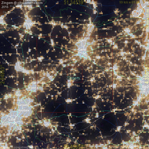
Analysis of Zingem night lights 2016
Square area 10x10 km:
 2.38%
2.38%90-99
3.36%80-89
2.66%70-79
4.06%60-69
4.9%50-59
8.96%40-49
6.16%30-39
8.82%20-29
26.89%10-19
21.57%0-9
10.22%Square area 50x50 km:
4.17%90-99
5.21%80-89
3.5%70-79
4.36%60-69
5.35%50-59
7.25%40-49
7.57%30-39
7.31%20-29
14.09%10-19
20.24%0-9
20.95%Clear (daylight) street map image can be seen on geolist.org.
Map coordinates:
51° 20' 43.4" North, 2° 56' 59.7" East
50° 54' 14.7" North, 3° 39' 11" East
50° 27' 30.9" North, 4° 21' 22.2" East
Some cities around Zingem sort by population:
• Oudenaarde
6.6 km =4.1 mi,  207°
207°
• Zottegem
11.7 km =7.3 mi,  109°
109°
• Merelbeke
12 km =7.5 mi,  32°
32°
• Oosterzele
11.5 km =7.1 mi,  62°
62°
• Gavere
2.9 km =1.8 mi,  12°
12°
• Nazareth
7.2 km =4.5 mi,  324°
324°
• De Pinte
9.9 km =6.2 mi,  357°
357°
• Kruishoutem
8.9 km =5.5 mi,  268°
268°
2783215 (p: 6,588)
Sources (retrieved 2019-11-25):
» Earth at Night: Flat Maps 2012, 2016