Gavere night lights from space
Night Light of Gavere (Flanders) from space (Belgium) Src. Average luminocity for 10x10km area is 38.2367% and for 50x50km: 37.0236%.
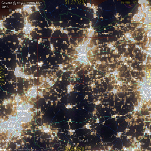
Analysis of Gavere night lights 2016
Square area 10x10 km:
 1.82%
1.82%90-99
3.08%80-89
2.8%70-79
3.92%60-69
5.88%50-59
10.78%40-49
11.06%30-39
14.01%20-29
25.77%10-19
16.67%0-9
4.2%Square area 50x50 km:
4.33%90-99
5.28%80-89
3.6%70-79
4.55%60-69
5.57%50-59
7.45%40-49
7.94%30-39
7.74%20-29
14.31%10-19
21.77%0-9
17.47%Clear (daylight) street map image can be seen on geolist.org.
Map coordinates:
51° 22' 12.8" North, 2° 57' 31.4" East
50° 55' 45" North, 3° 39' 42.6" East
50° 29' 2" North, 4° 21' 53.9" East
Some cities around Gavere sort by population:
• Oudenaarde
9.4 km =5.8 mi,  203°
203°
• Merelbeke
9.4 km =5.8 mi,  39°
39°
• Oosterzele
9.9 km =6.2 mi,  74°
74°
• Nazareth
5.6 km =3.5 mi,  303°
303°
• De Pinte
7.2 km =4.5 mi,  351°
351°
• Sint-Martens-Latem
9.6 km =6 mi, 349°
• Kruishoutem
10 km =6.2 mi,  252°
252°
• Zingem
2.9 km =1.8 mi,  192°
192°
2797798 (p: 11,888)
Sources (retrieved 2019-11-25):
» Earth at Night: Flat Maps 2012, 2016