Kalmthout night lights from space
Night Light of Kalmthout (Flanders) from space (Belgium) Src. Average luminocity for 10x10km area is 21.7143% and for 50x50km: 34.9253%.
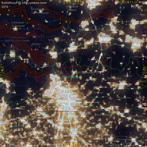
Analysis of Kalmthout night lights 2016
Square area 10x10 km:
 1.12%
1.12%90-99
1.68%80-89
2.1%70-79
2.24%60-69
3.08%50-59
1.68%40-49
3.5%30-39
4.76%20-29
9.8%10-19
37.39%0-9
32.63%Square area 50x50 km:
8.36%90-99
7.26%80-89
2.99%70-79
3.41%60-69
3.6%50-59
4.16%40-49
4.67%30-39
4.62%20-29
7.45%10-19
23.8%0-9
29.7%Clear (daylight) street map image can be seen on geolist.org.
Map coordinates:
51° 49' 16.1" North, 3° 46' 20.8" East
51° 23' 3.9" North, 4° 28' 32" East
50° 56' 36.6" North, 5° 10' 43.3" East
Some cities around Kalmthout sort by population:
• Brasschaat
10.4 km =6.5 mi,  173°
173°
• Schoten
14.8 km =9.2 mi, 172°
• Kapellen
8.3 km =5.2 mi,  199°
199°
• Brecht
11.9 km =7.4 mi,  108°
108°
• Wuustwezel
8.4 km =5.2 mi,  84°
84°
• Stabroek
9.3 km =5.8 mi,  231°
231°
• Essen
9.3 km =5.8 mi,  357°
357°
• Hoogerheide, NL
11.3 km =7 mi,  292°
292°
2794788 (p: 17,485)
Sources (retrieved 2019-11-25):
» Earth at Night: Flat Maps 2012, 2016