Jabbeke night lights from space
Night Light of Jabbeke (Flanders) from space (Belgium) Src. Average luminocity for 10x10km area is 28.5936% and for 50x50km: 20.9056%.
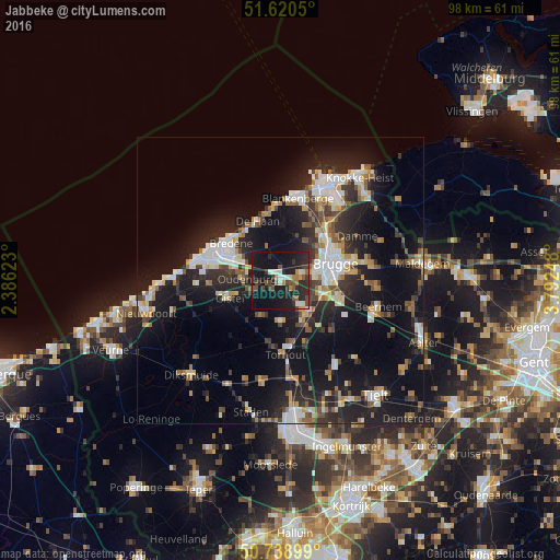
Analysis of Jabbeke night lights 2016
Square area 10x10 km:
 3.07%
3.07%90-99
4.41%80-89
0.27%70-79
2.14%60-69
2.94%50-59
4.28%40-49
6.15%30-39
4.14%20-29
15.11%10-19
47.86%0-9
9.63%Square area 50x50 km:
3.21%90-99
3.55%80-89
1.86%70-79
2.07%60-69
2.22%50-59
2.57%40-49
2.37%30-39
3.27%20-29
7.87%10-19
20.04%0-9
50.96%Clear (daylight) street map image can be seen on geolist.org.
Map coordinates:
51° 37' 13.8" North, 2° 23' 10.4" East
51° 10' 54.7" North, 3° 5' 21.7" East
50° 44' 20.4" North, 3° 47' 32.9" East
Some cities around Jabbeke sort by population:
• Brugge
9.9 km =6.2 mi,  72°
72°
• Zedelgem
5.5 km =3.4 mi,  143°
143°
• Oostkamp
10.4 km =6.5 mi,  107°
107°
• Bredene
9.9 km =6.2 mi,  306°
306°
• Ichtegem
10.9 km =6.8 mi,  208°
208°
• De Haan
10.8 km =6.7 mi,  339°
339°
• Gistel
9.2 km =5.7 mi,  251°
251°
• Oudenburg
6.2 km =3.9 mi,  273°
273°
2794999 (p: 13,488)
Sources (retrieved 2019-11-25):
» Earth at Night: Flat Maps 2012, 2016