Sint-Martens-Latem night lights from space
Night Light of Sint-Martens-Latem (Flanders) from space (Belgium) Src. Average luminocity for 10x10km area is 59.8222% and for 50x50km: 38.9339%.
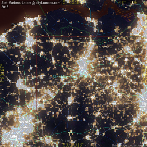
Analysis of Sint-Martens-Latem night lights 2016
Square area 10x10 km:
 8.29%
8.29%90-99
10.96%80-89
4.41%70-79
8.42%60-69
12.03%50-59
17.25%40-49
18.05%30-39
8.42%20-29
11.76%10-19
0.4%0-9
0%Square area 50x50 km:
4.61%90-99
5.74%80-89
3.67%70-79
5%60-69
6.06%50-59
7.46%40-49
8.31%30-39
7.94%20-29
14.56%10-19
23.54%0-9
13.12%Clear (daylight) street map image can be seen on geolist.org.
Map coordinates:
51° 27' 17.4" North, 2° 56' 4.8" East
51° 0' 52.5" North, 3° 38' 16" East
50° 34' 12.5" North, 4° 20' 27.3" East
Some cities around Sint-Martens-Latem sort by population:
• Gent
6.8 km =4.2 mi,  54°
54°
• Deinze
8.3 km =5.2 mi,  243°
243°
• Merelbeke
7.9 km =4.9 mi,  106°
106°
• Gavere
9.6 km =6 mi,  169°
169°
• Nevele
6.8 km =4.2 mi,  289°
289°
• Nazareth
7.1 km =4.4 mi,  205°
205°
• De Pinte
2.5 km =1.6 mi,  163°
163°
• Ledeberg
7.9 km =4.9 mi,  70°
70°
2786591 (p: 8,303)
Sources (retrieved 2019-11-25):
» Earth at Night: Flat Maps 2012, 2016