Parvez Ali night lights from space
Night Light of Parvez Ali (Dhaka) from space (Bangladesh) Src. Average luminocity for 10x10km area is 2.6825% and for 50x50km: 21.9771%.
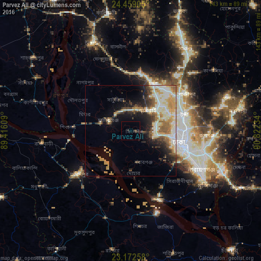
Analysis of Parvez Ali night lights 2016
Square area 10x10 km:
 0%
0%90-99
0%80-89
0%70-79
0%60-69
0%50-59
0%40-49
1.59%30-39
2.18%20-29
0.2%10-19
2.38%0-9
93.65%Square area 50x50 km:
2.94%90-99
6.24%80-89
2.95%70-79
3.26%60-69
2.44%50-59
2.56%40-49
2.88%30-39
2.59%20-29
4%10-19
7.43%0-9
62.72%Clear (daylight) street map image can be seen on geolist.org.
Map coordinates:
24° 27' 32.6" North, 89° 24' 57.9" East
23° 49' 2.7" North, 90° 7' 9.2" East
23° 10' 21.3" North, 90° 49' 20.4" East
Some cities around Parvez Ali sort by population:
• Dhaka
31.7 km =19.7 mi,  112°
112°
• Tungi
29.9 km =18.6 mi,  74°
74°
• Nāgarpur
36.3 km =22.6 mi,  317°
317°
• Paltan
31.3 km =19.4 mi, 106°
• Azimpur
28.8 km =17.9 mi, 109°
• Joymontop
5.7 km =3.5 mi,  125°
125°
• Dohār
25.1 km =15.6 mi,  174°
174°
• Mirzāpur
31.8 km =19.8 mi,  356°
356°
11609984 (p: 6,000)
Sources (retrieved 2019-11-25):
» Earth at Night: Flat Maps 2012, 2016