Crnići night lights from space
Night Light of Crnići (Federation of B&H) from space (Bosnia and Herzegovina) Src. Average luminocity for 10x10km area is 1.2227% and for 50x50km: 5.2548%.
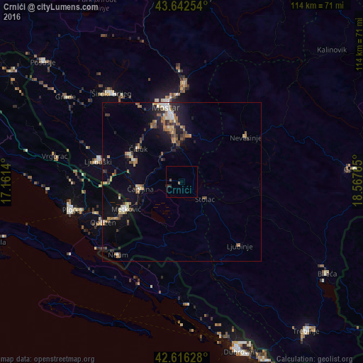
Analysis of Crnići night lights 2016
Square area 10x10 km:
 0%
0%90-99
0%80-89
0%70-79
0%60-69
0.61%50-59
0%40-49
0.61%30-39
0.45%20-29
1.36%10-19
0%0-9
96.97%Square area 50x50 km:
0.42%90-99
0.58%80-89
0.59%70-79
0.63%60-69
0.92%50-59
0.85%40-49
0.73%30-39
0.78%20-29
1.24%10-19
3.25%0-9
90.02%Clear (daylight) street map image can be seen on geolist.org.
Map coordinates:
43° 38' 33.1" North, 17° 9' 41" East
43° 7' 53.6" North, 17° 51' 52.3" East
42° 36' 58.6" North, 18° 34' 3.5" East
Some cities around Crnići sort by population:
• Mostar
24 km =14.9 mi,  349°
349°
• Metković, HR
19.5 km =12.1 mi,  243°
243°
• Ljubuški
26.9 km =16.7 mi,  285°
285°
• Čapljina
14.7 km =9.1 mi,  265°
265°
• Stolac
9.4 km =5.8 mi,  124°
124°
• Nevesinje
24.6 km =15.3 mi,  54°
54°
• Čitluk
17.1 km =10.6 mi,  309°
309°
• Rodoč
20.9 km =13 mi, 346°
3262021 (p: 5,789)
Sources (retrieved 2019-11-25):
» Earth at Night: Flat Maps 2012, 2016