Prozor night lights from space
Night Light of Prozor (Federation of B&H) from space (Bosnia and Herzegovina) Src. Average luminocity for 10x10km area is 0.9561% and for 50x50km: 0.3483%.
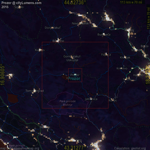
Analysis of Prozor night lights 2016
Square area 10x10 km:
 0%
0%90-99
0.61%80-89
0%70-79
0%60-69
0%50-59
0%40-49
0%30-39
0.61%20-29
0%10-19
0.61%0-9
98.18%Square area 50x50 km:
0.01%90-99
0.07%80-89
0.02%70-79
0%60-69
0.04%50-59
0.06%40-49
0.11%30-39
0.12%20-29
0.18%10-19
0.12%0-9
99.27%Clear (daylight) street map image can be seen on geolist.org.
Map coordinates:
44° 19' 38.5" North, 16° 54' 21.8" East
43° 49' 20" North, 17° 36' 33" East
43° 18' 46" North, 18° 18' 44.3" East
Some cities around Prozor sort by population:
• Bugojno
29 km =18 mi,  334°
334°
• Konjic
34.1 km =21.2 mi,  123°
123°
• Novi Travnik
39 km =24.2 mi,  5°
5°
• Fojnica
28.1 km =17.5 mi,  57°
57°
• Tomislavgrad
32.9 km =20.4 mi,  249°
249°
• Gornji Vakuf
13 km =8.1 mi,  352°
352°
• Jablanica
21.8 km =13.5 mi,  145°
145°
• Kačuni
37.7 km =23.4 mi,  44°
44°
3192279 (p: 10,349)
Sources (retrieved 2019-11-25):
» Earth at Night: Flat Maps 2012, 2016