Derventa night lights from space
Night Light of Derventa (Srpska) from space (Bosnia and Herzegovina) Src. Average luminocity for 10x10km area is 4.8524% and for 50x50km: 3.7233%.
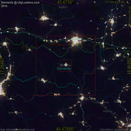
Analysis of Derventa night lights 2016
Square area 10x10 km:
 0.32%
0.32%90-99
0.32%80-89
0.16%70-79
1.11%60-69
1.43%50-59
1.75%40-49
0.63%30-39
0%20-29
0.95%10-19
0.95%0-9
92.38%Square area 50x50 km:
0.56%90-99
0.74%80-89
0.32%70-79
0.45%60-69
0.46%50-59
0.44%40-49
0.58%30-39
0.43%20-29
0.99%10-19
1.83%0-9
93.2%Clear (daylight) street map image can be seen on geolist.org.
Map coordinates:
45° 28' 25" North, 17° 12' 16.8" East
44° 58' 42.2" North, 17° 54' 28" East
44° 28' 43.9" North, 18° 36' 39.3" East
Some cities around Derventa sort by population:
• Slavonski Brod, HR
21.9 km =13.6 mi,  22°
22°
• Doboj
30.8 km =19.1 mi,  152°
152°
• Odžak
32.9 km =20.4 mi,  81°
81°
• Brod
18.8 km =11.7 mi, 19°
• Srbac
33 km =20.5 mi,  293°
293°
• Prnjavor
22.7 km =14.1 mi,  238°
238°
• Kalenderovci Donji
6.5 km =4 mi, 237°
• Tešanjka
35 km =21.7 mi,  166°
166°
3202081 (p: 9,773)
Sources (retrieved 2019-11-25):
» Earth at Night: Flat Maps 2012, 2016