Yaycı night lights from space
Night Light of Yaycı (Nakhichevan) from space (Azerbaijan) Src. Average luminocity for 10x10km area is 3.4541% and for 50x50km: 3.6657%.
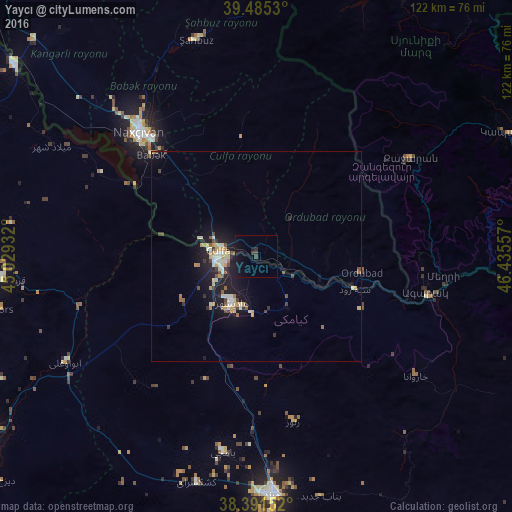
Analysis of Yaycı night lights 2016
Square area 10x10 km:
 0%
0%90-99
0%80-89
0%70-79
0%60-69
0%50-59
0.34%40-49
1.36%30-39
0.68%20-29
0.68%10-19
7.48%0-9
89.46%Square area 50x50 km:
0.26%90-99
0.7%80-89
0.51%70-79
0.58%60-69
0.21%50-59
0.43%40-49
0.45%30-39
0.49%20-29
0.62%10-19
4.11%0-9
91.65%Clear (daylight) street map image can be seen on geolist.org.
Map coordinates:
39° 29' 7.1" North, 45° 1' 45.6" East
38° 56' 25.9" North, 45° 43' 56.8" East
38° 23' 29.5" North, 46° 26' 8.1" East
Some cities around Yaycı sort by population:
• Marand, IR
56.6 km =35.2 mi,  176°
176°
• Nakhchivan
40.7 km =25.3 mi,  317°
317°
• Kapan, AM
65.3 km =40.6 mi,  62°
62°
• Qarah Ẕīā’ od Dīn, IR
61.4 km =38.2 mi,  264°
264°
• Hats’avan, AM
61.7 km =38.3 mi,  19°
19°
• Culfa
9 km =5.6 mi,  279°
279°
• Ordubad
25.3 km =15.7 mi,  97°
97°
• Cahri
52.9 km =32.9 mi,  328°
328°
146958 (p: 8,500)
Sources (retrieved 2019-11-25):
» Earth at Night: Flat Maps 2012, 2016