Severo-Vostotchnyi Bank night lights from space
Night Light of Severo-Vostotchnyi Bank (Neftçala) from space (Azerbaijan) Src. Average luminocity for 10x10km area is 6.1905% and for 50x50km: 1.5072%.
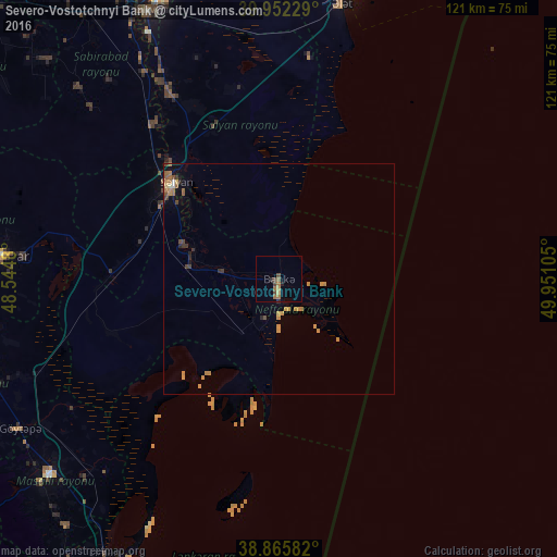
Analysis of Severo-Vostotchnyi Bank night lights 2016
Square area 10x10 km:
 0%
0%90-99
0%80-89
0.51%70-79
0.85%60-69
2.72%50-59
0.68%40-49
2.72%30-39
0.68%20-29
0.85%10-19
0.51%0-9
90.48%Square area 50x50 km:
0.01%90-99
0.05%80-89
0.1%70-79
0.63%60-69
0.35%50-59
0.18%40-49
0.34%30-39
0.18%20-29
0.2%10-19
0.26%0-9
97.69%Clear (daylight) street map image can be seen on geolist.org.
Map coordinates:
39° 57' 8.2" North, 48° 32' 41.3" East
39° 24' 40.2" North, 49° 14' 52.5" East
38° 51' 57" North, 49° 57' 3.8" East
Some cities around Severo-Vostotchnyi Bank sort by population:
• Şirvan
64.6 km =40.1 mi,  335°
335°
• Salyan
30.5 km =19 mi,  312°
312°
• Jalilabad
68.8 km =42.8 mi,  250°
250°
• Neftçala
3.8 km =2.4 mi,  181°
181°
• Pushkino
60.6 km =37.7 mi,  274°
274°
• Prishibinskoye
65 km =40.4 mi,  240°
240°
• Masally
65.3 km =40.6 mi,  230°
230°
• Boradigah
70.8 km =44 mi,  220°
220°
148375 (p: 7,075)
Sources (retrieved 2019-11-25):
» Earth at Night: Flat Maps 2012, 2016