Woongarrah night lights from space
Night Light of Woongarrah (New South Wales) from space (Australia) Src. Average luminocity for 10x10km area is 30.4545% and for 50x50km: 8.7747%.
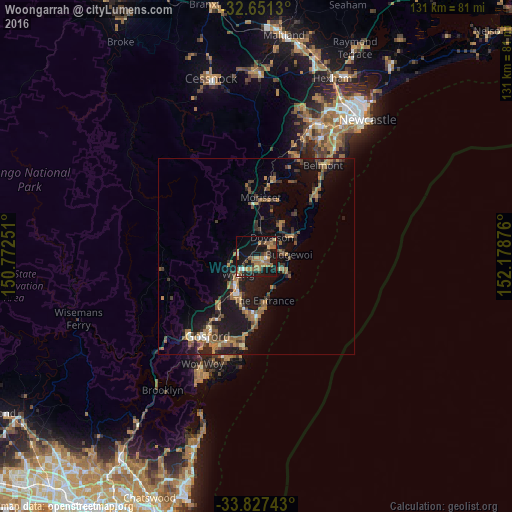
Analysis of Woongarrah night lights 2016
Square area 10x10 km:
 1.57%
1.57%90-99
1.57%80-89
2.1%70-79
5.24%60-69
9.62%50-59
8.57%40-49
2.45%30-39
5.07%20-29
5.07%10-19
40.56%0-9
18.18%Square area 50x50 km:
0.35%90-99
0.39%80-89
0.46%70-79
1.24%60-69
2.44%50-59
1.92%40-49
1.19%30-39
1.99%20-29
2.04%10-19
10.06%0-9
77.92%Clear (daylight) street map image can be seen on geolist.org.
Map coordinates:
32° 39' 4.7" South, 150° 46' 21" East
33° 14' 28.8" South, 151° 28' 32.3" East
33° 49' 38.7" South, 152° 10' 43.5" East
Some cities around Woongarrah sort by population:
• Bateau Bay
15.8 km =9.8 mi,  183°
183°
• Gorokan
3.6 km =2.2 mi,  119°
119°
• Berkeley Vale
12.7 km =7.9 mi,  198°
198°
• Killarney Vale
13.6 km =8.5 mi,  186°
186°
• Long Jetty
13.2 km =8.2 mi,  174°
174°
• Blue Haven
4.2 km =2.6 mi,  37°
37°
• Hamlyn Terrace
1.1 km =0.7 mi, 176°
• Lake Munmorah
11.1 km =6.9 mi,  63°
63°
8348014 (p: 5,147)
Sources (retrieved 2019-11-25):
» Earth at Night: Flat Maps 2012, 2016