Cambridge Park night lights from space
Night Light of Cambridge Park (New South Wales) from space (Australia) Src. Average luminocity for 10x10km area is 66.3718% and for 50x50km: 27.6845%.
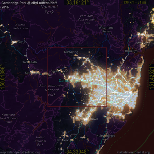
Analysis of Cambridge Park night lights 2016
Square area 10x10 km:
 14.1%
14.1%90-99
12.27%80-89
7.33%70-79
10.99%60-69
18.68%50-59
7.51%40-49
9.16%30-39
10.62%20-29
8.06%10-19
1.28%0-9
0%Square area 50x50 km:
5.66%90-99
6.64%80-89
3.63%70-79
4.57%60-69
4.53%50-59
2.27%40-49
2.65%30-39
3.35%20-29
4.28%10-19
6.85%0-9
55.58%Clear (daylight) street map image can be seen on geolist.org.
Map coordinates:
33° 9' 40.4" South, 150° 1' 8.3" East
33° 44' 52.2" South, 150° 43' 19.5" East
34° 19' 49.7" South, 151° 25' 30.8" East
Some cities around Cambridge Park sort by population:
• Cranebrook
4.8 km =3 mi,  345°
345°
• Penrith
2.1 km =1.3 mi,  263°
263°
• Kingswood Park
2.2 km =1.4 mi,  198°
198°
• South Penrith
3.8 km =2.4 mi,  221°
221°
• Emu Plains
5.1 km =3.2 mi,  267°
267°
• Ropes Crossing
6.6 km =4.1 mi,  75°
75°
• Jamisontown
4.7 km =2.9 mi,  241°
241°
• Jordan Springs
3 km =1.9 mi,  11°
11°
9972622 (p: 6,646)
Sources (retrieved 2019-11-25):
» Earth at Night: Flat Maps 2012, 2016